You are here: Home > Network List > TA - USArray Transportable Network (new EarthScope stations) Stations List
> Station J16K Anvik River, AK, USA > Earthquake Result Viewer
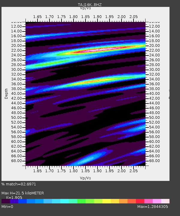
J16K Anvik River, AK, USA - Earthquake Result Viewer
| Earthquake location: |
Mindoro, Philippines |
| Earthquake latitude/longitude: |
13.8/120.6 |
| Earthquake time(UTC): |
2020/12/24 (359) 23:43:42 GMT |
| Earthquake Depth: |
114 km |
| Earthquake Magnitude: |
6.3 Mww |
| Earthquake Catalog/Contributor: |
NEIC PDE/us |
|
| Network: |
TA USArray Transportable Network (new EarthScope stations) |
| Station: |
J16K Anvik River, AK, USA |
| Lat/Lon: |
63.28 N/160.60 W |
| Elevation: |
328 m |
|
| Distance: |
72.7 deg |
| Az: |
27.665 deg |
| Baz: |
266.291 deg |
| Ray Param: |
0.05321366 |
| Estimated Moho Depth: |
21.5 km |
| Estimated Crust Vp/Vs: |
1.90 |
| Assumed Crust Vp: |
6.276 km/s |
| Estimated Crust Vs: |
3.294 km/s |
| Estimated Crust Poisson's Ratio: |
0.31 |
|
| Radial Match: |
82.6971 % |
| Radial Bump: |
375 |
| Transverse Match: |
70.611534 % |
| Transverse Bump: |
400 |
| SOD ConfigId: |
23341671 |
| Insert Time: |
2021-01-08 00:58:16.774 +0000 |
| GWidth: |
2.5 |
| Max Bumps: |
400 |
| Tol: |
0.001 |
|

Signal To Noise
| Channel | StoN | STA | LTA |
| TA:J16K: :BHZ:20201224T23:54:27.200029Z | 10.551866 | 2.3786436E-6 | 2.25424E-7 |
| TA:J16K: :BHN:20201224T23:54:27.200029Z | 1.7387117 | 4.845063E-7 | 2.7865818E-7 |
| TA:J16K: :BHE:20201224T23:54:27.200029Z | 5.8200154 | 1.0719568E-6 | 1.8418454E-7 |
| Arrivals |
| Ps | 3.2 SECOND |
| PpPs | 9.7 SECOND |
| PsPs/PpSs | 13 SECOND |


