You are here: Home > Network List > US - United States National Seismic Network Stations List
> Station ERPA Erie, Pennsylvania, USA > Earthquake Result Viewer
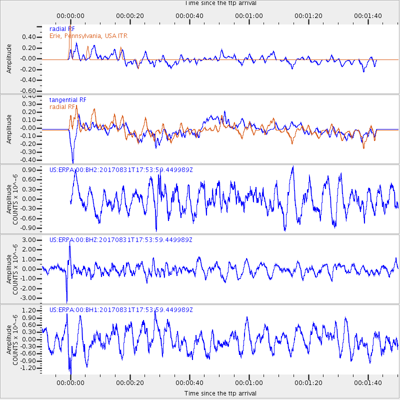
ERPA Erie, Pennsylvania, USA - Earthquake Result Viewer
*The percent match for this event was below the threshold and hence no stack was calculated.
| Earthquake location: |
Kodiak Island Region, Alaska |
| Earthquake latitude/longitude: |
58.5/-153.7 |
| Earthquake time(UTC): |
2017/08/31 (243) 17:46:02 GMT |
| Earthquake Depth: |
62 km |
| Earthquake Magnitude: |
5.5 ml |
| Earthquake Catalog/Contributor: |
NEIC PDE/ak |
|
| Network: |
US United States National Seismic Network |
| Station: |
ERPA Erie, Pennsylvania, USA |
| Lat/Lon: |
42.12 N/79.99 W |
| Elevation: |
306 m |
|
| Distance: |
47.3 deg |
| Az: |
76.358 deg |
| Baz: |
316.626 deg |
| Ray Param: |
$rayparam |
*The percent match for this event was below the threshold and hence was not used in the summary stack. |
|
| Radial Match: |
42.20744 % |
| Radial Bump: |
400 |
| Transverse Match: |
67.87097 % |
| Transverse Bump: |
400 |
| SOD ConfigId: |
2364251 |
| Insert Time: |
2017-10-09 19:07:28.014 +0000 |
| GWidth: |
2.5 |
| Max Bumps: |
400 |
| Tol: |
0.001 |
|
Signal To Noise
| Channel | StoN | STA | LTA |
| US:ERPA:00:BHZ:20170831T17:53:59.449989Z | 2.3783948 | 7.8642586E-7 | 3.3065405E-7 |
| US:ERPA:00:BH1:20170831T17:53:59.449989Z | 1.549028 | 6.7777745E-7 | 4.3755014E-7 |
| US:ERPA:00:BH2:20170831T17:53:59.449989Z | 1.2255554 | 3.8303298E-7 | 3.125383E-7 |
| Arrivals |
| Ps | |
| PpPs | |
| PsPs/PpSs | |


