You are here: Home > Network List > AV - Alaska Volcano Observatory Stations List
> Station MAPS Pakushin Southeast, Makushin Volcano, Alaska > Earthquake Result Viewer
MAPS Pakushin Southeast, Makushin Volcano, Alaska - Earthquake Result Viewer
*The percent match for this event was below the threshold and hence no stack was calculated.
| Earthquake location: |
Turkey |
| Earthquake latitude/longitude: |
38.5/39.2 |
| Earthquake time(UTC): |
2020/12/27 (362) 06:37:33 GMT |
| Earthquake Depth: |
10 km |
| Earthquake Magnitude: |
5.5 Mww |
| Earthquake Catalog/Contributor: |
NEIC PDE/us |
|
| Network: |
AV Alaska Volcano Observatory |
| Station: |
MAPS Pakushin Southeast, Makushin Volcano, Alaska |
| Lat/Lon: |
53.81 N/166.94 W |
| Elevation: |
333 m |
|
| Distance: |
85.4 deg |
| Az: |
15.209 deg |
| Baz: |
339.682 deg |
| Ray Param: |
$rayparam |
*The percent match for this event was below the threshold and hence was not used in the summary stack. |
|
| Radial Match: |
59.015087 % |
| Radial Bump: |
400 |
| Transverse Match: |
47.5601 % |
| Transverse Bump: |
394 |
| SOD ConfigId: |
23341671 |
| Insert Time: |
2021-01-10 07:40:46.199 +0000 |
| GWidth: |
2.5 |
| Max Bumps: |
400 |
| Tol: |
0.001 |
|
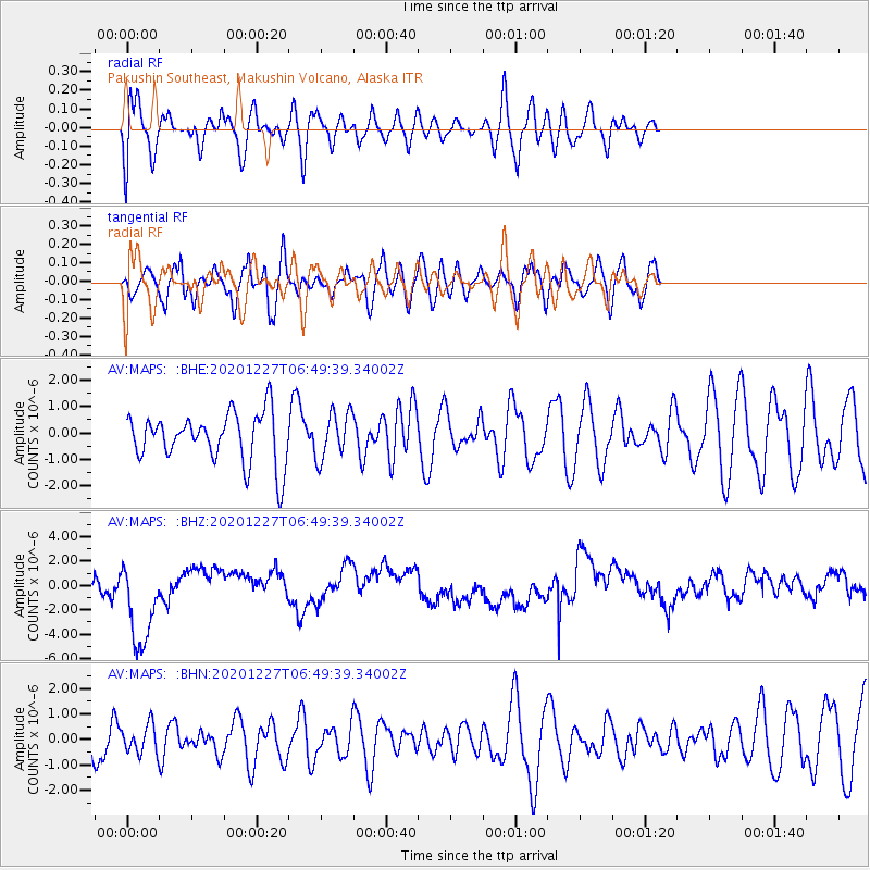
Signal To Noise
| Channel | StoN | STA | LTA |
| AV:MAPS: :BHZ:20201227T06:49:39.34002Z | 3.283814 | 3.667185E-6 | 1.1167457E-6 |
| AV:MAPS: :BHN:20201227T06:49:39.34002Z | 0.47804725 | 5.511937E-7 | 1.1530109E-6 |
| AV:MAPS: :BHE:20201227T06:49:39.34002Z | 0.93692034 | 8.7624693E-7 | 9.352417E-7 |
| Arrivals |
| Ps | |
| PpPs | |
| PsPs/PpSs | |


