You are here: Home > Network List > IU - Global Seismograph Network (GSN - IRIS/USGS) Stations List
> Station POHA Pohakuloa, Hawaii, USA > Earthquake Result Viewer
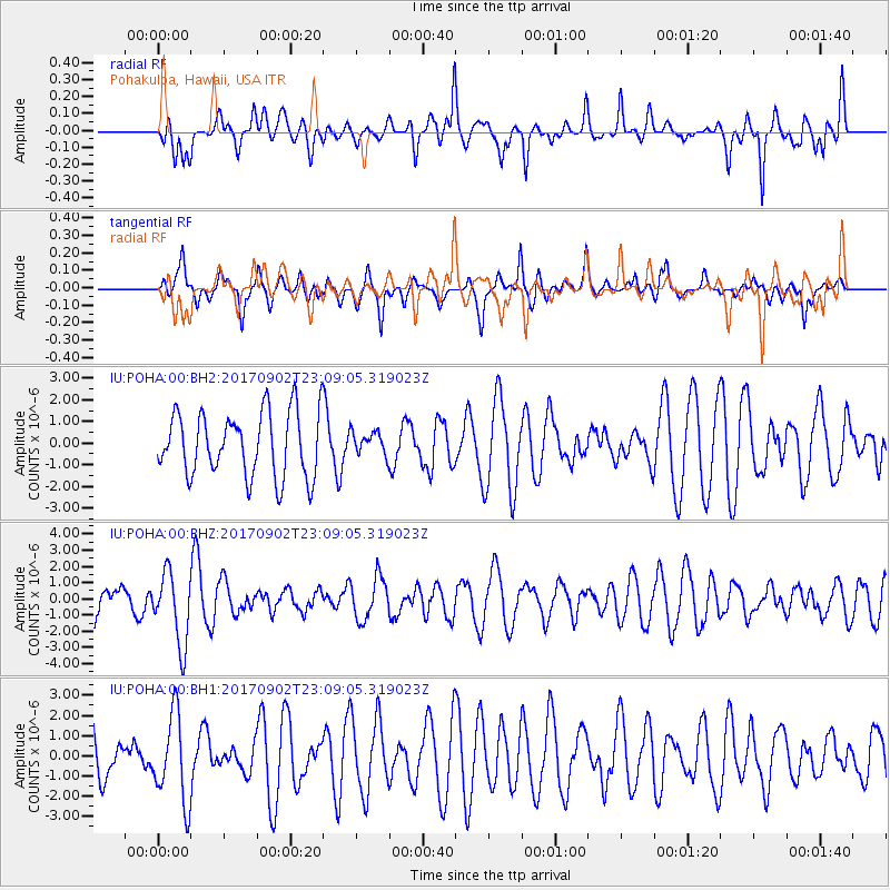
POHA Pohakuloa, Hawaii, USA - Earthquake Result Viewer
*The percent match for this event was below the threshold and hence no stack was calculated.
| Earthquake location: |
Mariana Islands |
| Earthquake latitude/longitude: |
14.0/146.7 |
| Earthquake time(UTC): |
2017/09/02 (245) 23:00:01 GMT |
| Earthquake Depth: |
10 km |
| Earthquake Magnitude: |
5.5 mb |
| Earthquake Catalog/Contributor: |
NEIC PDE/us |
|
| Network: |
IU Global Seismograph Network (GSN - IRIS/USGS) |
| Station: |
POHA Pohakuloa, Hawaii, USA |
| Lat/Lon: |
19.76 N/155.53 W |
| Elevation: |
1990 m |
|
| Distance: |
55.4 deg |
| Az: |
75.55 deg |
| Baz: |
273.681 deg |
| Ray Param: |
$rayparam |
*The percent match for this event was below the threshold and hence was not used in the summary stack. |
|
| Radial Match: |
58.138424 % |
| Radial Bump: |
395 |
| Transverse Match: |
43.710922 % |
| Transverse Bump: |
353 |
| SOD ConfigId: |
2364251 |
| Insert Time: |
2017-10-09 19:12:40.602 +0000 |
| GWidth: |
2.5 |
| Max Bumps: |
400 |
| Tol: |
0.001 |
|
Signal To Noise
| Channel | StoN | STA | LTA |
| IU:POHA:00:BHZ:20170902T23:09:05.319023Z | 1.4412619 | 2.2036597E-6 | 1.5289794E-6 |
| IU:POHA:00:BH1:20170902T23:09:05.319023Z | 1.185903 | 2.1539365E-6 | 1.8162841E-6 |
| IU:POHA:00:BH2:20170902T23:09:05.319023Z | 0.3846739 | 5.597483E-7 | 1.4551241E-6 |
| Arrivals |
| Ps | |
| PpPs | |
| PsPs/PpSs | |


