You are here: Home > Network List > US - United States National Seismic Network Stations List
> Station WMOK Wichita Mountains, Oklahoma, USA > Earthquake Result Viewer
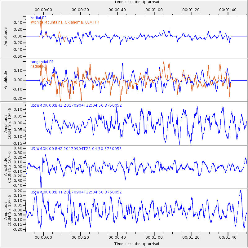
WMOK Wichita Mountains, Oklahoma, USA - Earthquake Result Viewer
*The percent match for this event was below the threshold and hence no stack was calculated.
| Earthquake location: |
Near Coast Of Northern Chile |
| Earthquake latitude/longitude: |
-19.3/-70.0 |
| Earthquake time(UTC): |
2017/09/04 (247) 21:55:20 GMT |
| Earthquake Depth: |
63 km |
| Earthquake Magnitude: |
5.1 Mwr |
| Earthquake Catalog/Contributor: |
NEIC PDE/us |
|
| Network: |
US United States National Seismic Network |
| Station: |
WMOK Wichita Mountains, Oklahoma, USA |
| Lat/Lon: |
34.74 N/98.78 W |
| Elevation: |
486 m |
|
| Distance: |
60.3 deg |
| Az: |
332.868 deg |
| Baz: |
148.465 deg |
| Ray Param: |
$rayparam |
*The percent match for this event was below the threshold and hence was not used in the summary stack. |
|
| Radial Match: |
53.305172 % |
| Radial Bump: |
400 |
| Transverse Match: |
56.657734 % |
| Transverse Bump: |
400 |
| SOD ConfigId: |
2364251 |
| Insert Time: |
2017-10-09 19:23:58.468 +0000 |
| GWidth: |
2.5 |
| Max Bumps: |
400 |
| Tol: |
0.001 |
|
Signal To Noise
| Channel | StoN | STA | LTA |
| US:WMOK:00:BHZ:20170904T22:04:50.375005Z | 1.4443265 | 1.3676596E-7 | 9.4691856E-8 |
| US:WMOK:00:BH1:20170904T22:04:50.375005Z | 1.4159117 | 8.0383195E-8 | 5.6771334E-8 |
| US:WMOK:00:BH2:20170904T22:04:50.375005Z | 1.2086632 | 3.9466578E-8 | 3.265308E-8 |
| Arrivals |
| Ps | |
| PpPs | |
| PsPs/PpSs | |


