You are here: Home > Network List > GS - US Geological Survey Networks Stations List
> Station DEC09 Decatur Surface Seismic Site, Decatur, IL, USA > Earthquake Result Viewer
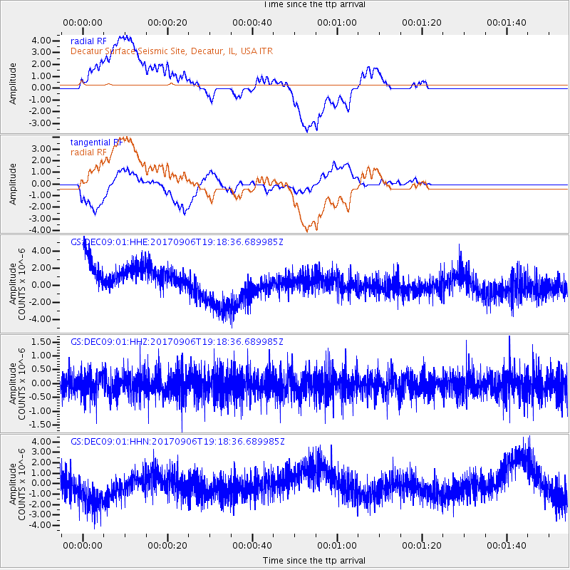
DEC09 Decatur Surface Seismic Site, Decatur, IL, USA - Earthquake Result Viewer
*The percent match for this event was below the threshold and hence no stack was calculated.
| Earthquake location: |
Tonga Islands |
| Earthquake latitude/longitude: |
-15.4/-173.6 |
| Earthquake time(UTC): |
2017/09/06 (249) 19:05:48 GMT |
| Earthquake Depth: |
56 km |
| Earthquake Magnitude: |
5.1 mb |
| Earthquake Catalog/Contributor: |
NEIC PDE/us |
|
| Network: |
GS US Geological Survey Networks |
| Station: |
DEC09 Decatur Surface Seismic Site, Decatur, IL, USA |
| Lat/Lon: |
39.87 N/88.92 W |
| Elevation: |
207 m |
|
| Distance: |
95.8 deg |
| Az: |
50.37 deg |
| Baz: |
254.87 deg |
| Ray Param: |
$rayparam |
*The percent match for this event was below the threshold and hence was not used in the summary stack. |
|
| Radial Match: |
31.767656 % |
| Radial Bump: |
400 |
| Transverse Match: |
14.676777 % |
| Transverse Bump: |
400 |
| SOD ConfigId: |
2364251 |
| Insert Time: |
2017-10-09 19:27:10.614 +0000 |
| GWidth: |
2.5 |
| Max Bumps: |
400 |
| Tol: |
0.001 |
|
Signal To Noise
| Channel | StoN | STA | LTA |
| GS:DEC09:01:HHZ:20170906T19:18:36.689985Z | 1.1711321 | 4.3374462E-7 | 3.7036352E-7 |
| GS:DEC09:01:HHN:20170906T19:18:36.689985Z | 1.7518103 | 2.7114047E-6 | 1.547773E-6 |
| GS:DEC09:01:HHE:20170906T19:18:36.689985Z | 3.426144 | 3.9690276E-6 | 1.1584533E-6 |
| Arrivals |
| Ps | |
| PpPs | |
| PsPs/PpSs | |


