You are here: Home > Network List > IU - Global Seismograph Network (GSN - IRIS/USGS) Stations List
> Station PMG Port Moresby, New Guinea > Earthquake Result Viewer
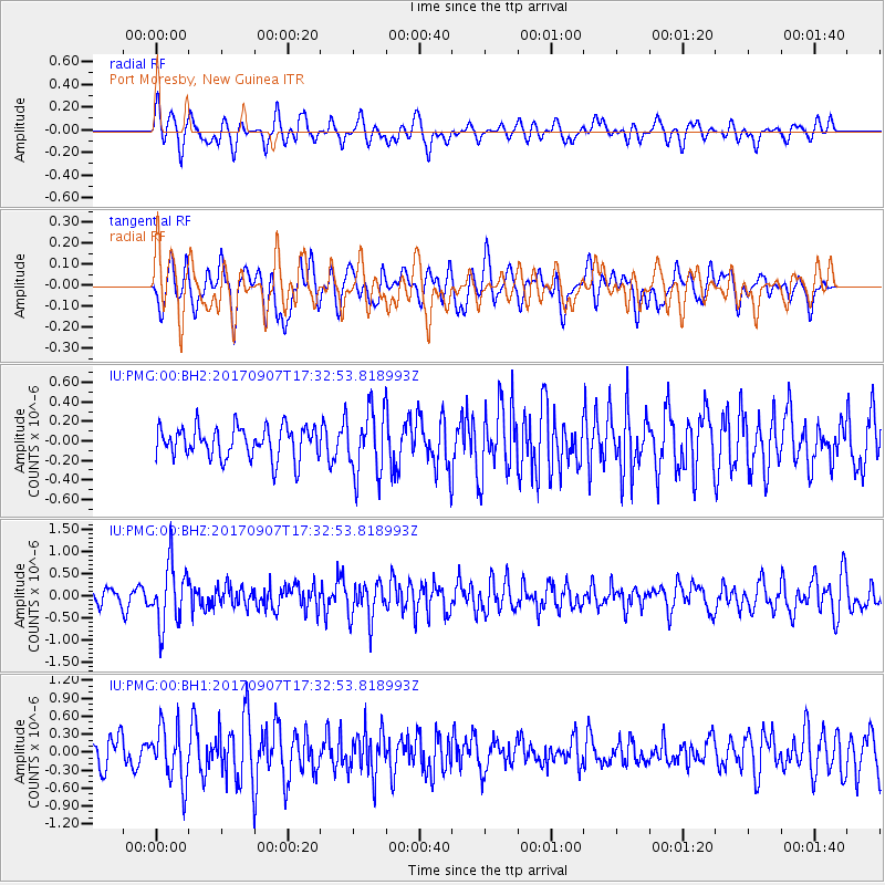
PMG Port Moresby, New Guinea - Earthquake Result Viewer
*The percent match for this event was below the threshold and hence no stack was calculated.
| Earthquake location: |
Bonin Islands, Japan Region |
| Earthquake latitude/longitude: |
27.8/139.8 |
| Earthquake time(UTC): |
2017/09/07 (250) 17:26:49 GMT |
| Earthquake Depth: |
448 km |
| Earthquake Magnitude: |
6.1 Mww |
| Earthquake Catalog/Contributor: |
NEIC PDE/us |
|
| Network: |
IU Global Seismograph Network (GSN - IRIS/USGS) |
| Station: |
PMG Port Moresby, New Guinea |
| Lat/Lon: |
9.40 S/147.16 E |
| Elevation: |
90 m |
|
| Distance: |
37.6 deg |
| Az: |
168.07 deg |
| Baz: |
349.301 deg |
| Ray Param: |
$rayparam |
*The percent match for this event was below the threshold and hence was not used in the summary stack. |
|
| Radial Match: |
63.688263 % |
| Radial Bump: |
400 |
| Transverse Match: |
57.107822 % |
| Transverse Bump: |
400 |
| SOD ConfigId: |
2364251 |
| Insert Time: |
2017-10-09 19:30:40.648 +0000 |
| GWidth: |
2.5 |
| Max Bumps: |
400 |
| Tol: |
0.001 |
|
Signal To Noise
| Channel | StoN | STA | LTA |
| IU:PMG:00:BHZ:20170907T17:32:53.818993Z | 4.519337 | 6.843333E-7 | 1.5142338E-7 |
| IU:PMG:00:BH1:20170907T17:32:53.818993Z | 1.8977606 | 4.57754E-7 | 2.4120743E-7 |
| IU:PMG:00:BH2:20170907T17:32:53.818993Z | 2.0378113 | 3.284167E-7 | 1.6116148E-7 |
| Arrivals |
| Ps | |
| PpPs | |
| PsPs/PpSs | |


