You are here: Home > Network List > US - United States National Seismic Network Stations List
> Station ACSO Alum Creek State Park, Ohio, USA > Earthquake Result Viewer
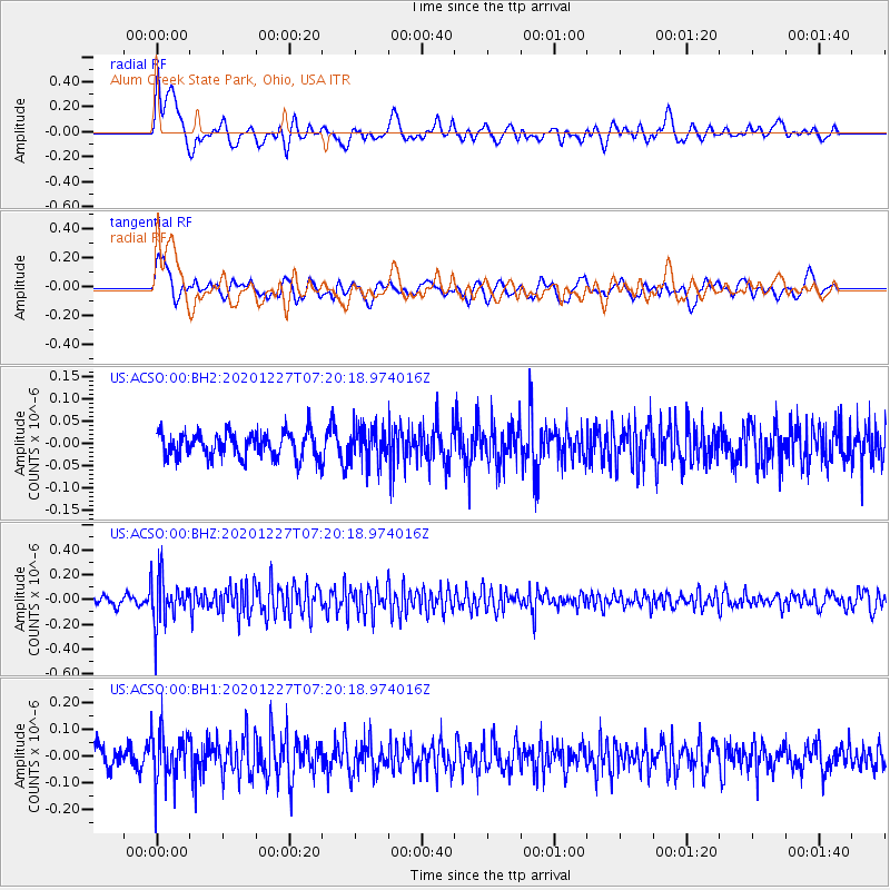
ACSO Alum Creek State Park, Ohio, USA - Earthquake Result Viewer
*The percent match for this event was below the threshold and hence no stack was calculated.
| Earthquake location: |
Near Coast Of Peru |
| Earthquake latitude/longitude: |
-16.0/-74.3 |
| Earthquake time(UTC): |
2020/12/27 (362) 07:11:10 GMT |
| Earthquake Depth: |
34 km |
| Earthquake Magnitude: |
5.7 Mww |
| Earthquake Catalog/Contributor: |
NEIC PDE/us |
|
| Network: |
US United States National Seismic Network |
| Station: |
ACSO Alum Creek State Park, Ohio, USA |
| Lat/Lon: |
40.23 N/82.98 W |
| Elevation: |
288 m |
|
| Distance: |
56.5 deg |
| Az: |
352.078 deg |
| Baz: |
170.031 deg |
| Ray Param: |
$rayparam |
*The percent match for this event was below the threshold and hence was not used in the summary stack. |
|
| Radial Match: |
61.81617 % |
| Radial Bump: |
400 |
| Transverse Match: |
64.419044 % |
| Transverse Bump: |
400 |
| SOD ConfigId: |
23341671 |
| Insert Time: |
2021-01-10 08:32:00.042 +0000 |
| GWidth: |
2.5 |
| Max Bumps: |
400 |
| Tol: |
0.001 |
|
Signal To Noise
| Channel | StoN | STA | LTA |
| US:ACSO:00:BHZ:20201227T07:20:18.974016Z | 6.936396 | 1.8943096E-7 | 2.7309708E-8 |
| US:ACSO:00:BH1:20201227T07:20:18.974016Z | 2.911697 | 9.295097E-8 | 3.19233E-8 |
| US:ACSO:00:BH2:20201227T07:20:18.974016Z | 1.4353487 | 4.0240597E-8 | 2.8035414E-8 |
| Arrivals |
| Ps | |
| PpPs | |
| PsPs/PpSs | |


