You are here: Home > Network List > US - United States National Seismic Network Stations List
> Station WMOK Wichita Mountains, Oklahoma, USA > Earthquake Result Viewer
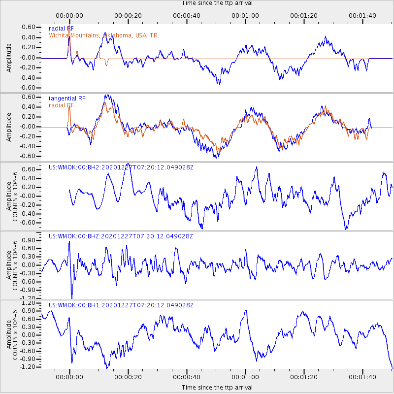
WMOK Wichita Mountains, Oklahoma, USA - Earthquake Result Viewer
*The percent match for this event was below the threshold and hence no stack was calculated.
| Earthquake location: |
Near Coast Of Peru |
| Earthquake latitude/longitude: |
-16.0/-74.3 |
| Earthquake time(UTC): |
2020/12/27 (362) 07:11:10 GMT |
| Earthquake Depth: |
34 km |
| Earthquake Magnitude: |
5.7 Mww |
| Earthquake Catalog/Contributor: |
NEIC PDE/us |
|
| Network: |
US United States National Seismic Network |
| Station: |
WMOK Wichita Mountains, Oklahoma, USA |
| Lat/Lon: |
34.74 N/98.78 W |
| Elevation: |
486 m |
|
| Distance: |
55.6 deg |
| Az: |
335.604 deg |
| Baz: |
151.167 deg |
| Ray Param: |
$rayparam |
*The percent match for this event was below the threshold and hence was not used in the summary stack. |
|
| Radial Match: |
36.826607 % |
| Radial Bump: |
400 |
| Transverse Match: |
30.139011 % |
| Transverse Bump: |
400 |
| SOD ConfigId: |
23341671 |
| Insert Time: |
2021-01-10 08:32:48.803 +0000 |
| GWidth: |
2.5 |
| Max Bumps: |
400 |
| Tol: |
0.001 |
|
Signal To Noise
| Channel | StoN | STA | LTA |
| US:WMOK:00:BHZ:20201227T07:20:12.049028Z | 2.5346642 | 4.6320997E-7 | 1.8275004E-7 |
| US:WMOK:00:BH1:20201227T07:20:12.049028Z | 1.5931624 | 6.214629E-7 | 3.900813E-7 |
| US:WMOK:00:BH2:20201227T07:20:12.049028Z | 1.0755289 | 2.6837233E-7 | 2.4952593E-7 |
| Arrivals |
| Ps | |
| PpPs | |
| PsPs/PpSs | |


