You are here: Home > Network List > C0 - Colorado Geological Survey Seismic Network Stations List
> Station CHIL CSU-CHILL Radar > Earthquake Result Viewer
CHIL CSU-CHILL Radar - Earthquake Result Viewer
| Earthquake location: |
Off Coast Of Central Chile |
| Earthquake latitude/longitude: |
-39.3/-74.9 |
| Earthquake time(UTC): |
2020/12/27 (362) 21:39:15 GMT |
| Earthquake Depth: |
10 km |
| Earthquake Magnitude: |
6.7 mww |
| Earthquake Catalog/Contributor: |
NEIC PDE/us |
|
| Network: |
C0 Colorado Geological Survey Seismic Network |
| Station: |
CHIL CSU-CHILL Radar |
| Lat/Lon: |
40.45 N/104.64 W |
| Elevation: |
1424 m |
|
| Distance: |
83.9 deg |
| Az: |
337.633 deg |
| Baz: |
157.255 deg |
| Ray Param: |
0.045841806 |
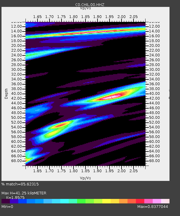
| Estimated Moho Depth: |
41.25 km |
| Estimated Crust Vp/Vs: |
1.96 |
| Assumed Crust Vp: |
6.306 km/s |
| Estimated Crust Vs: |
3.221 km/s |
| Estimated Crust Poisson's Ratio: |
0.32 |
|
| Radial Match: |
85.62315 % |
| Radial Bump: |
326 |
| Transverse Match: |
78.61917 % |
| Transverse Bump: |
400 |
| SOD ConfigId: |
23341671 |
| Insert Time: |
2021-01-10 22:42:34.175 +0000 |
| GWidth: |
2.5 |
| Max Bumps: |
400 |
| Tol: |
0.001 |
|

Signal To Noise
| Channel | StoN | STA | LTA |
| C0:CHIL:00:HHZ:20201227T21:51:14.105021Z | 23.523998 | 2.0854065E-6 | 8.8650175E-8 |
| C0:CHIL:00:HHN:20201227T21:51:14.105021Z | 2.4992979 | 5.769587E-7 | 2.3084831E-7 |
| C0:CHIL:00:HHE:20201227T21:51:14.105021Z | 1.1346574 | 2.9364088E-7 | 2.5879257E-7 |
| Arrivals |
| Ps | 6.4 SECOND |
| PpPs | 19 SECOND |
| PsPs/PpSs | 25 SECOND |


