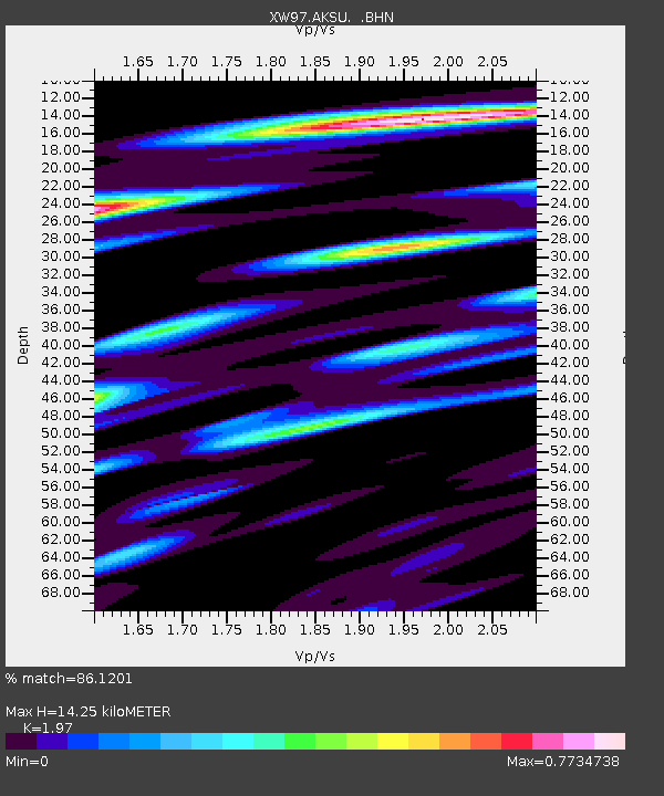
AKSU XW.AKSU - Earthquake Result Viewer
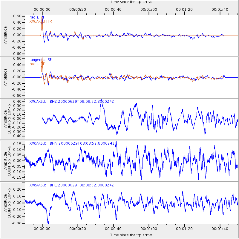
Earthquake location: Mariana Islands
Earthquake latitude/longitude: 13.0/144.5
Earthquake time(UTC): 2000/06/29 (181) 07:59:06 GMT
Earthquake Depth: 52 km
Earthquake Magnitude: 5.5 MB, 5.5 MS, 5.9 MW, 5.8 MW
Earthquake Catalog/Contributor: WHDF/NEIC
Network: XW Tien Shan Continental Dynamics
Station: AKSU XW.AKSU
Lat/Lon: 41.14 N/80.11 E
Elevation: 1109 m
Distance: 62.3 deg
Az: 309.708 deg
Baz: 96.909 deg
Ray Param: 0.06018646
Estimated Moho Depth: 14.25 km
Estimated Crust Vp/Vs: 1.97
Assumed Crust Vp: 6.129 km/s
Estimated Crust Vs: 3.111 km/s
Estimated Crust Poisson's Ratio: 0.33
Radial Match: 86.1201 %
Radial Bump: 400
Transverse Match: 79.28879 %
Transverse Bump: 400
SOD ConfigId: 20082
Insert Time: 2010-02-26 15:13:46.018 +0000
GWidth: 2.5
Max Bumps: 400
Tol: 0.001

Signal To Noise

ChannelStoNSTALTA
XW:AKSU: :BHN:20000629T08:08:52.800024Z1.64729815.3598253E-83.253707E-8
XW:AKSU: :BHE:20000629T08:08:52.800024Z3.90506821.3378397E-73.4259063E-8
XW:AKSU: :BHZ:20000629T08:08:52.800024Z4.672982.1596044E-74.6214716E-8
Arrivals
Ps2.3 SECOND
PpPs6.7 SECOND
PsPs/PpSs9.0 SECOND