You are here: Home > Network List > II - Global Seismograph Network (GSN - IRIS/IDA) Stations List
> Station WRAB Tennant Creek, NT, Australia > Earthquake Result Viewer
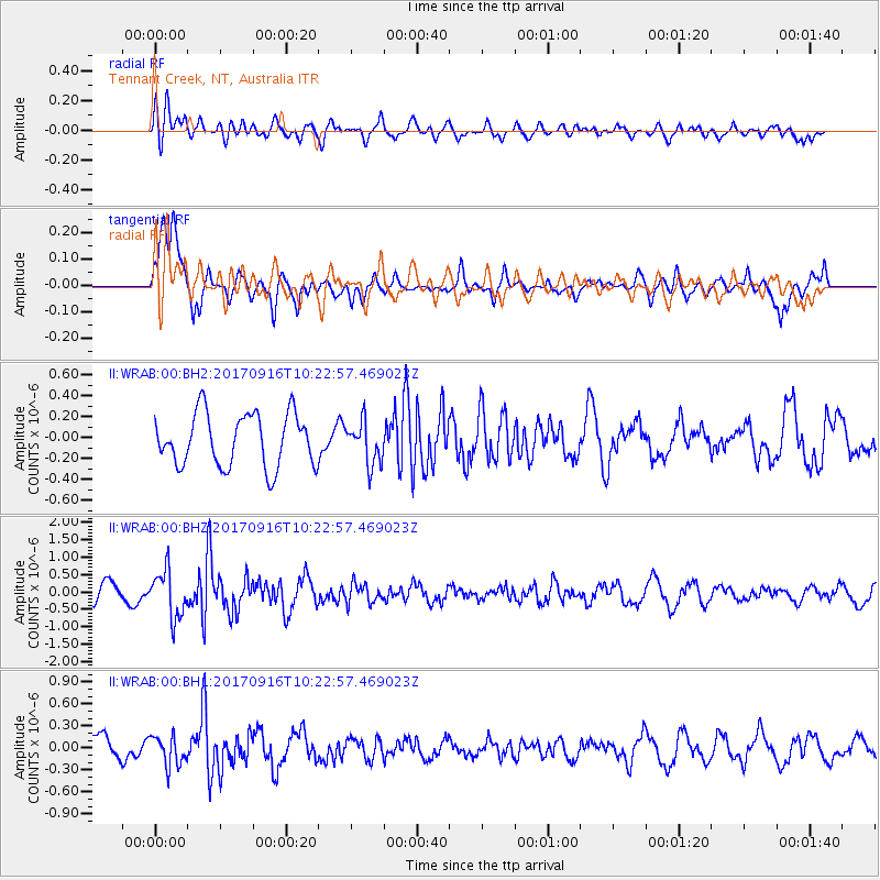
WRAB Tennant Creek, NT, Australia - Earthquake Result Viewer
*The percent match for this event was below the threshold and hence no stack was calculated.
| Earthquake location: |
Northern Xinjiang, China |
| Earthquake latitude/longitude: |
42.2/83.5 |
| Earthquake time(UTC): |
2017/09/16 (259) 10:11:33 GMT |
| Earthquake Depth: |
16 km |
| Earthquake Magnitude: |
5.4 Mww |
| Earthquake Catalog/Contributor: |
NEIC PDE/us |
|
| Network: |
II Global Seismograph Network (GSN - IRIS/IDA) |
| Station: |
WRAB Tennant Creek, NT, Australia |
| Lat/Lon: |
19.93 S/134.36 E |
| Elevation: |
366 m |
|
| Distance: |
77.6 deg |
| Az: |
131.674 deg |
| Baz: |
323.852 deg |
| Ray Param: |
$rayparam |
*The percent match for this event was below the threshold and hence was not used in the summary stack. |
|
| Radial Match: |
47.474392 % |
| Radial Bump: |
400 |
| Transverse Match: |
74.43996 % |
| Transverse Bump: |
400 |
| SOD ConfigId: |
2364251 |
| Insert Time: |
2017-10-09 20:04:31.259 +0000 |
| GWidth: |
2.5 |
| Max Bumps: |
400 |
| Tol: |
0.001 |
|
Signal To Noise
| Channel | StoN | STA | LTA |
| II:WRAB:00:BHZ:20170916T10:22:57.469023Z | 2.3229048 | 6.7631044E-7 | 2.9114858E-7 |
| II:WRAB:00:BH1:20170916T10:22:57.469023Z | 1.4669461 | 2.0357297E-7 | 1.387733E-7 |
| II:WRAB:00:BH2:20170916T10:22:57.469023Z | 0.8038655 | 2.0111587E-7 | 2.5018596E-7 |
| Arrivals |
| Ps | |
| PpPs | |
| PsPs/PpSs | |


