You are here: Home > Network List > IU - Global Seismograph Network (GSN - IRIS/USGS) Stations List
> Station RSSD Black Hills, South Dakota, USA > Earthquake Result Viewer
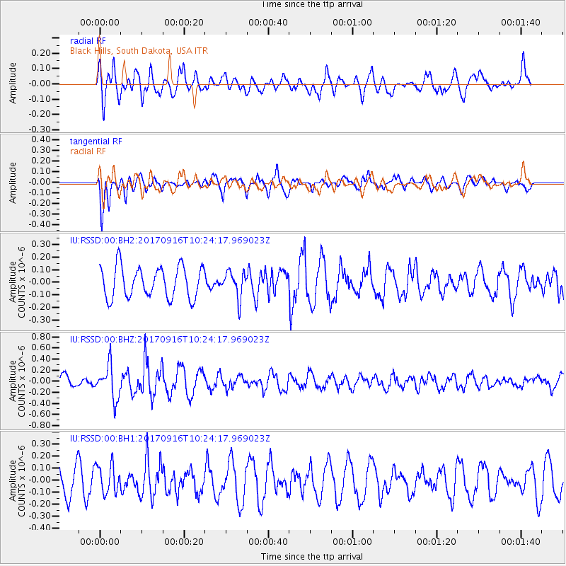
RSSD Black Hills, South Dakota, USA - Earthquake Result Viewer
*The percent match for this event was below the threshold and hence no stack was calculated.
| Earthquake location: |
Northern Xinjiang, China |
| Earthquake latitude/longitude: |
42.2/83.5 |
| Earthquake time(UTC): |
2017/09/16 (259) 10:11:33 GMT |
| Earthquake Depth: |
16 km |
| Earthquake Magnitude: |
5.4 Mww |
| Earthquake Catalog/Contributor: |
NEIC PDE/us |
|
| Network: |
IU Global Seismograph Network (GSN - IRIS/USGS) |
| Station: |
RSSD Black Hills, South Dakota, USA |
| Lat/Lon: |
44.12 N/104.04 W |
| Elevation: |
2090 m |
|
| Distance: |
93.8 deg |
| Az: |
5.443 deg |
| Baz: |
354.384 deg |
| Ray Param: |
$rayparam |
*The percent match for this event was below the threshold and hence was not used in the summary stack. |
|
| Radial Match: |
50.192593 % |
| Radial Bump: |
400 |
| Transverse Match: |
64.975464 % |
| Transverse Bump: |
400 |
| SOD ConfigId: |
2364251 |
| Insert Time: |
2017-10-09 20:04:53.373 +0000 |
| GWidth: |
2.5 |
| Max Bumps: |
400 |
| Tol: |
0.001 |
|
Signal To Noise
| Channel | StoN | STA | LTA |
| IU:RSSD:00:BHZ:20170916T10:24:17.969023Z | 2.177868 | 3.1117932E-7 | 1.4288254E-7 |
| IU:RSSD:00:BH1:20170916T10:24:17.969023Z | 1.3989267 | 1.1649284E-7 | 8.3273015E-8 |
| IU:RSSD:00:BH2:20170916T10:24:17.969023Z | 0.84526503 | 1.0456759E-7 | 1.2370982E-7 |
| Arrivals |
| Ps | |
| PpPs | |
| PsPs/PpSs | |


