You are here: Home > Network List > CO - South Carolina Seismic Network Stations List
> Station PAULI CO:PAULI > Earthquake Result Viewer
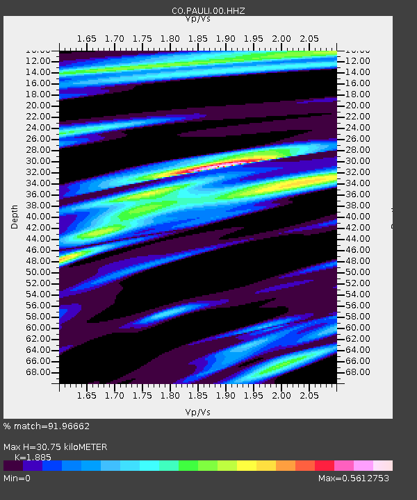
PAULI CO:PAULI - Earthquake Result Viewer
| Earthquake location: |
Off Coast Of Central Chile |
| Earthquake latitude/longitude: |
-39.3/-74.9 |
| Earthquake time(UTC): |
2020/12/27 (362) 21:39:15 GMT |
| Earthquake Depth: |
10 km |
| Earthquake Magnitude: |
6.7 mww |
| Earthquake Catalog/Contributor: |
NEIC PDE/us |
|
| Network: |
CO South Carolina Seismic Network |
| Station: |
PAULI CO:PAULI |
| Lat/Lon: |
34.82 N/81.81 W |
| Elevation: |
179 m |
|
| Distance: |
74.1 deg |
| Az: |
354.1 deg |
| Baz: |
174.44 deg |
| Ray Param: |
0.052590836 |
| Estimated Moho Depth: |
30.75 km |
| Estimated Crust Vp/Vs: |
1.88 |
| Assumed Crust Vp: |
6.419 km/s |
| Estimated Crust Vs: |
3.405 km/s |
| Estimated Crust Poisson's Ratio: |
0.30 |
|
| Radial Match: |
91.96662 % |
| Radial Bump: |
285 |
| Transverse Match: |
74.31968 % |
| Transverse Bump: |
400 |
| SOD ConfigId: |
23341671 |
| Insert Time: |
2021-01-10 22:47:02.409 +0000 |
| GWidth: |
2.5 |
| Max Bumps: |
400 |
| Tol: |
0.001 |
|

Signal To Noise
| Channel | StoN | STA | LTA |
| CO:PAULI:00:HHZ:20201227T21:50:20.319987Z | 20.286083 | 4.959725E-6 | 2.4448906E-7 |
| CO:PAULI:00:HHN:20201227T21:50:20.319987Z | 10.627134 | 1.9634485E-6 | 1.8475804E-7 |
| CO:PAULI:00:HHE:20201227T21:50:20.319987Z | 2.9097502 | 3.7587031E-7 | 1.2917614E-7 |
| Arrivals |
| Ps | 4.4 SECOND |
| PpPs | 13 SECOND |
| PsPs/PpSs | 18 SECOND |


