You are here: Home > Network List > GS - US Geological Survey Networks Stations List
> Station VEA2 VEA1 > Earthquake Result Viewer
VEA2 VEA1 - Earthquake Result Viewer
| Earthquake location: |
Off Coast Of Central Chile |
| Earthquake latitude/longitude: |
-39.3/-74.9 |
| Earthquake time(UTC): |
2020/12/27 (362) 21:39:15 GMT |
| Earthquake Depth: |
10 km |
| Earthquake Magnitude: |
6.7 mww |
| Earthquake Catalog/Contributor: |
NEIC PDE/us |
|
| Network: |
GS US Geological Survey Networks |
| Station: |
VEA2 VEA1 |
| Lat/Lon: |
34.94 N/106.46 W |
| Elevation: |
1844 m |
|
| Distance: |
79.5 deg |
| Az: |
334.077 deg |
| Baz: |
155.63 deg |
| Ray Param: |
0.04894595 |
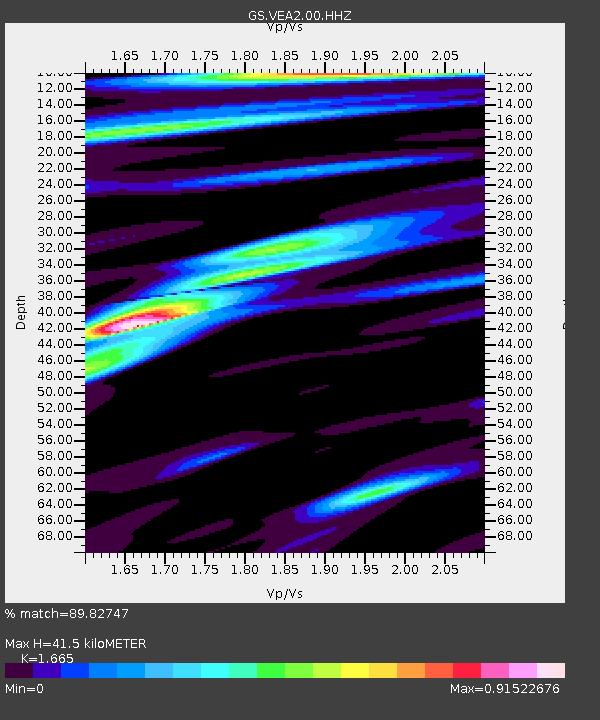
| Estimated Moho Depth: |
41.5 km |
| Estimated Crust Vp/Vs: |
1.66 |
| Assumed Crust Vp: |
6.502 km/s |
| Estimated Crust Vs: |
3.905 km/s |
| Estimated Crust Poisson's Ratio: |
0.22 |
|
| Radial Match: |
89.82747 % |
| Radial Bump: |
400 |
| Transverse Match: |
87.699135 % |
| Transverse Bump: |
400 |
| SOD ConfigId: |
23341671 |
| Insert Time: |
2021-01-10 22:49:25.939 +0000 |
| GWidth: |
2.5 |
| Max Bumps: |
400 |
| Tol: |
0.001 |
|

Signal To Noise
| Channel | StoN | STA | LTA |
| GS:VEA2:00:HHZ:20201227T21:50:50.668986Z | 17.228518 | 2.5348413E-6 | 1.4713055E-7 |
| GS:VEA2:00:HH1:20201227T21:50:50.668986Z | 5.4096804 | 8.4883993E-7 | 1.5691128E-7 |
| GS:VEA2:00:HH2:20201227T21:50:50.668986Z | 2.3522582 | 3.1172252E-7 | 1.3252054E-7 |
| Arrivals |
| Ps | 4.4 SECOND |
| PpPs | 16 SECOND |
| PsPs/PpSs | 21 SECOND |


