You are here: Home > Network List > PF - Volcanologic Network of Piton de Fournaise-OVPF Stations List
> Station HIM cratere Himiltrude > Earthquake Result Viewer
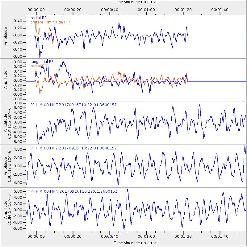
HIM cratere Himiltrude - Earthquake Result Viewer
*The percent match for this event was below the threshold and hence no stack was calculated.
| Earthquake location: |
Northern Xinjiang, China |
| Earthquake latitude/longitude: |
42.2/83.5 |
| Earthquake time(UTC): |
2017/09/16 (259) 10:11:33 GMT |
| Earthquake Depth: |
16 km |
| Earthquake Magnitude: |
5.4 Mww |
| Earthquake Catalog/Contributor: |
NEIC PDE/us |
|
| Network: |
PF Volcanologic Network of Piton de Fournaise-OVPF |
| Station: |
HIM cratere Himiltrude |
| Lat/Lon: |
21.21 S/55.72 E |
| Elevation: |
1958 m |
|
| Distance: |
68.1 deg |
| Az: |
207.96 deg |
| Baz: |
21.921 deg |
| Ray Param: |
$rayparam |
*The percent match for this event was below the threshold and hence was not used in the summary stack. |
|
| Radial Match: |
45.70651 % |
| Radial Bump: |
400 |
| Transverse Match: |
38.215015 % |
| Transverse Bump: |
400 |
| SOD ConfigId: |
2364251 |
| Insert Time: |
2017-10-09 20:05:54.186 +0000 |
| GWidth: |
2.5 |
| Max Bumps: |
400 |
| Tol: |
0.001 |
|
Signal To Noise
| Channel | StoN | STA | LTA |
| PF:HIM:00:HHZ:20170916T10:22:01.360015Z | 0.77573913 | 1.3881101E-6 | 1.7894032E-6 |
| PF:HIM:00:HHN:20170916T10:22:01.360015Z | 0.90450984 | 2.1488415E-6 | 2.3756975E-6 |
| PF:HIM:00:HHE:20170916T10:22:01.360015Z | 1.3575634 | 4.250792E-6 | 3.131192E-6 |
| Arrivals |
| Ps | |
| PpPs | |
| PsPs/PpSs | |


