You are here: Home > Network List > N4 - Central and EAstern US Network Stations List
> Station E38A The Farm, Brule, WI, USA > Earthquake Result Viewer
E38A The Farm, Brule, WI, USA - Earthquake Result Viewer
| Earthquake location: |
Off Coast Of Central Chile |
| Earthquake latitude/longitude: |
-39.3/-74.9 |
| Earthquake time(UTC): |
2020/12/27 (362) 21:39:15 GMT |
| Earthquake Depth: |
10 km |
| Earthquake Magnitude: |
6.7 mww |
| Earthquake Catalog/Contributor: |
NEIC PDE/us |
|
| Network: |
N4 Central and EAstern US Network |
| Station: |
E38A The Farm, Brule, WI, USA |
| Lat/Lon: |
46.61 N/91.55 W |
| Elevation: |
341 m |
|
| Distance: |
86.9 deg |
| Az: |
348.596 deg |
| Baz: |
167.151 deg |
| Ray Param: |
0.043748338 |
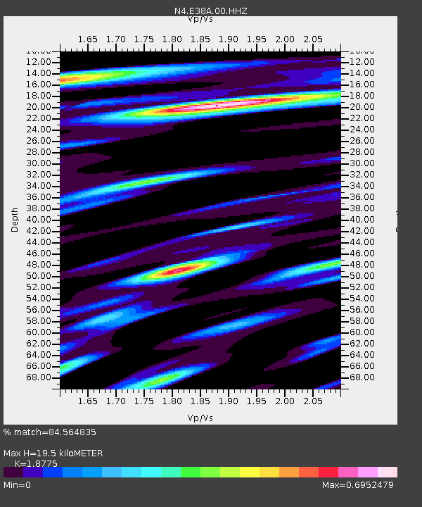
| Estimated Moho Depth: |
19.5 km |
| Estimated Crust Vp/Vs: |
1.88 |
| Assumed Crust Vp: |
6.467 km/s |
| Estimated Crust Vs: |
3.444 km/s |
| Estimated Crust Poisson's Ratio: |
0.30 |
|
| Radial Match: |
84.564835 % |
| Radial Bump: |
400 |
| Transverse Match: |
71.702835 % |
| Transverse Bump: |
400 |
| SOD ConfigId: |
23341671 |
| Insert Time: |
2021-01-10 22:52:02.130 +0000 |
| GWidth: |
2.5 |
| Max Bumps: |
400 |
| Tol: |
0.001 |
|

Signal To Noise
| Channel | StoN | STA | LTA |
| N4:E38A:00:HHZ:20201227T21:51:28.689982Z | 18.366297 | 6.3639213E-6 | 3.4649997E-7 |
| N4:E38A:00:HH1:20201227T21:51:28.689982Z | 3.131449 | 1.2600148E-6 | 4.0237435E-7 |
| N4:E38A:00:HH2:20201227T21:51:28.689982Z | 1.6542513 | 6.156695E-7 | 3.721741E-7 |
| Arrivals |
| Ps | 2.7 SECOND |
| PpPs | 8.5 SECOND |
| PsPs/PpSs | 11 SECOND |


