You are here: Home > Network List > N4 - Central and EAstern US Network Stations List
> Station H43A Windswept, Luxemburg, WI, USA > Earthquake Result Viewer
H43A Windswept, Luxemburg, WI, USA - Earthquake Result Viewer
| Earthquake location: |
Off Coast Of Central Chile |
| Earthquake latitude/longitude: |
-39.3/-74.9 |
| Earthquake time(UTC): |
2020/12/27 (362) 21:39:15 GMT |
| Earthquake Depth: |
10 km |
| Earthquake Magnitude: |
6.7 mww |
| Earthquake Catalog/Contributor: |
NEIC PDE/us |
|
| Network: |
N4 Central and EAstern US Network |
| Station: |
H43A Windswept, Luxemburg, WI, USA |
| Lat/Lon: |
44.47 N/87.77 W |
| Elevation: |
274 m |
|
| Distance: |
84.2 deg |
| Az: |
350.786 deg |
| Baz: |
170.014 deg |
| Ray Param: |
0.045624893 |
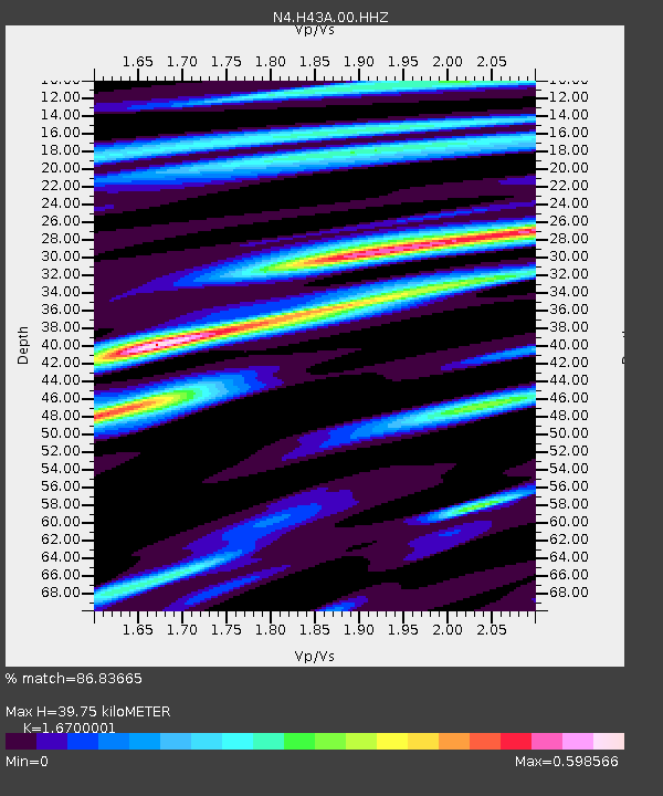
| Estimated Moho Depth: |
39.75 km |
| Estimated Crust Vp/Vs: |
1.67 |
| Assumed Crust Vp: |
6.53 km/s |
| Estimated Crust Vs: |
3.91 km/s |
| Estimated Crust Poisson's Ratio: |
0.22 |
|
| Radial Match: |
86.83665 % |
| Radial Bump: |
400 |
| Transverse Match: |
75.41157 % |
| Transverse Bump: |
400 |
| SOD ConfigId: |
23341671 |
| Insert Time: |
2021-01-10 22:52:14.288 +0000 |
| GWidth: |
2.5 |
| Max Bumps: |
400 |
| Tol: |
0.001 |
|

Signal To Noise
| Channel | StoN | STA | LTA |
| N4:H43A:00:HHZ:20201227T21:51:15.699016Z | 18.70065 | 5.3987237E-6 | 2.886918E-7 |
| N4:H43A:00:HH1:20201227T21:51:15.699016Z | 8.492963 | 1.9237598E-6 | 2.2651221E-7 |
| N4:H43A:00:HH2:20201227T21:51:15.699016Z | 2.3936038 | 4.6269096E-7 | 1.9330307E-7 |
| Arrivals |
| Ps | 4.2 SECOND |
| PpPs | 16 SECOND |
| PsPs/PpSs | 20 SECOND |


