You are here: Home > Network List > XW97 - Tien Shan Continental Dynamics Stations List
> Station AKSU XW.AKSU > Earthquake Result Viewer
AKSU XW.AKSU - Earthquake Result Viewer
| Earthquake location: |
Mariana Islands |
| Earthquake latitude/longitude: |
14.1/145.0 |
| Earthquake time(UTC): |
2000/06/21 (173) 16:25:06 GMT |
| Earthquake Depth: |
112 km |
| Earthquake Magnitude: |
5.7 MB, 6.0 MW, 5.9 MW |
| Earthquake Catalog/Contributor: |
WHDF/NEIC |
|
| Network: |
XW Tien Shan Continental Dynamics |
| Station: |
AKSU XW.AKSU |
| Lat/Lon: |
41.14 N/80.11 E |
| Elevation: |
1109 m |
|
| Distance: |
62.0 deg |
| Az: |
309.229 deg |
| Baz: |
95.674 deg |
| Ray Param: |
0.06022462 |
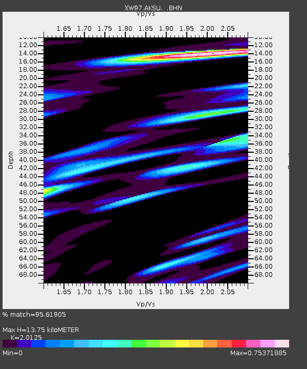
| Estimated Moho Depth: |
13.75 km |
| Estimated Crust Vp/Vs: |
2.01 |
| Assumed Crust Vp: |
6.129 km/s |
| Estimated Crust Vs: |
3.045 km/s |
| Estimated Crust Poisson's Ratio: |
0.34 |
|
| Radial Match: |
95.61905 % |
| Radial Bump: |
301 |
| Transverse Match: |
90.15197 % |
| Transverse Bump: |
400 |
| SOD ConfigId: |
20082 |
| Insert Time: |
2010-02-26 15:13:48.759 +0000 |
| GWidth: |
2.5 |
| Max Bumps: |
400 |
| Tol: |
0.001 |
|
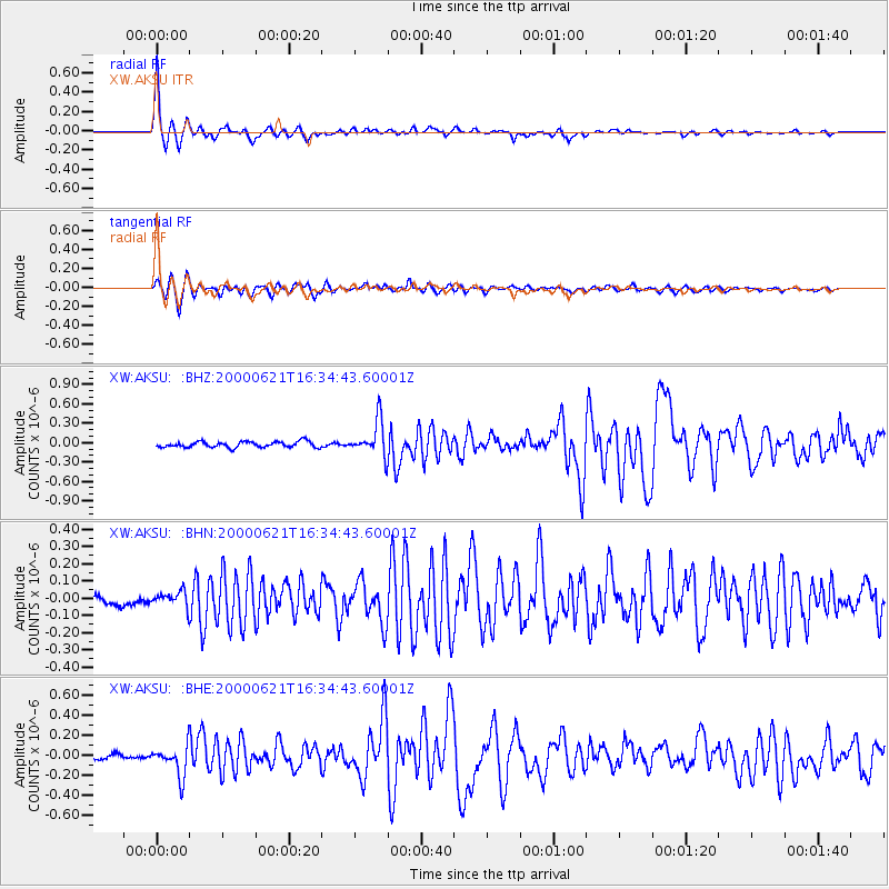
Signal To Noise
| Channel | StoN | STA | LTA |
| XW:AKSU: :BHN:20000621T16:34:43.60001Z | 1.6410581 | 4.195717E-8 | 2.5567145E-8 |
| XW:AKSU: :BHE:20000621T16:34:43.60001Z | 5.3086257 | 1.4996422E-7 | 2.8249161E-8 |
| XW:AKSU: :BHZ:20000621T16:34:43.60001Z | 6.0448313 | 2.7259196E-7 | 4.509505E-8 |
| Arrivals |
| Ps | 2.4 SECOND |
| PpPs | 6.5 SECOND |
| PsPs/PpSs | 8.9 SECOND |


