You are here: Home > Network List > NN - Western Great Basin/Eastern Sierra Nevada Stations List
> Station LCH Last Chance Range, CA. (GPS 01/04/2001) w84 > Earthquake Result Viewer
LCH Last Chance Range, CA. (GPS 01/04/2001) w84 - Earthquake Result Viewer
| Earthquake location: |
Off Coast Of Central Chile |
| Earthquake latitude/longitude: |
-39.3/-74.9 |
| Earthquake time(UTC): |
2020/12/27 (362) 21:39:15 GMT |
| Earthquake Depth: |
10 km |
| Earthquake Magnitude: |
6.7 mww |
| Earthquake Catalog/Contributor: |
NEIC PDE/us |
|
| Network: |
NN Western Great Basin/Eastern Sierra Nevada |
| Station: |
LCH Last Chance Range, CA. (GPS 01/04/2001) w84 |
| Lat/Lon: |
37.23 N/117.65 W |
| Elevation: |
1414 m |
|
| Distance: |
85.7 deg |
| Az: |
327.106 deg |
| Baz: |
148.156 deg |
| Ray Param: |
0.04454226 |
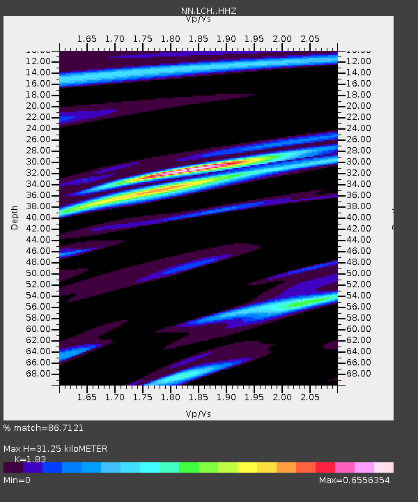
| Estimated Moho Depth: |
31.25 km |
| Estimated Crust Vp/Vs: |
1.83 |
| Assumed Crust Vp: |
6.279 km/s |
| Estimated Crust Vs: |
3.431 km/s |
| Estimated Crust Poisson's Ratio: |
0.29 |
|
| Radial Match: |
86.7121 % |
| Radial Bump: |
322 |
| Transverse Match: |
72.88948 % |
| Transverse Bump: |
400 |
| SOD ConfigId: |
23341671 |
| Insert Time: |
2021-01-10 22:55:44.594 +0000 |
| GWidth: |
2.5 |
| Max Bumps: |
400 |
| Tol: |
0.001 |
|

Signal To Noise
| Channel | StoN | STA | LTA |
| NN:LCH: :HHZ:20201227T21:51:23.248027Z | 6.4608955 | 2.6118412E-6 | 4.0425374E-7 |
| NN:LCH: :HHN:20201227T21:51:23.248027Z | 4.096135 | 8.8378107E-7 | 2.1575974E-7 |
| NN:LCH: :HHE:20201227T21:51:23.248027Z | 2.5446777 | 5.304627E-7 | 2.084597E-7 |
| Arrivals |
| Ps | 4.2 SECOND |
| PpPs | 14 SECOND |
| PsPs/PpSs | 18 SECOND |


