You are here: Home > Network List > GE - GEOFON Stations List
> Station MRNI GII Station Mount Meron, Israel > Earthquake Result Viewer
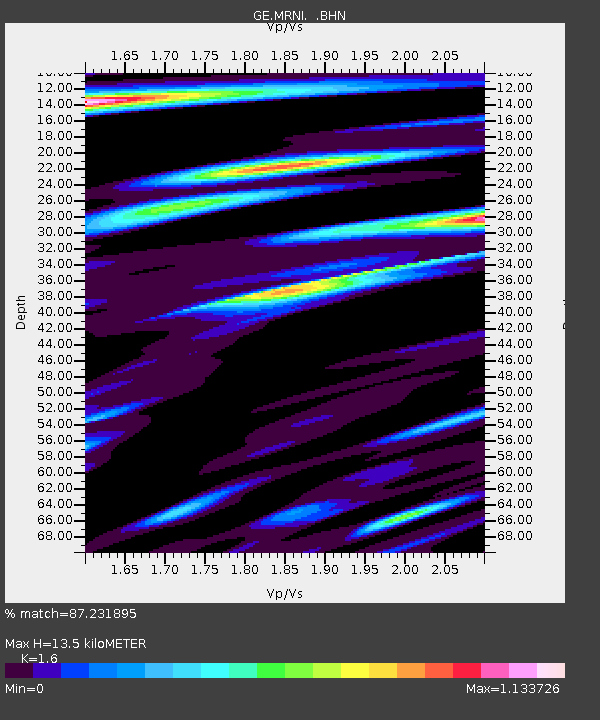
MRNI GII Station Mount Meron, Israel - Earthquake Result Viewer
| Earthquake location: |
Qinghai, China |
| Earthquake latitude/longitude: |
35.4/99.3 |
| Earthquake time(UTC): |
2000/09/12 (256) 00:27:58 GMT |
| Earthquake Depth: |
10 km |
| Earthquake Magnitude: |
5.7 MB, 6.3 MS, 6.1 MW, 6.1 MW |
| Earthquake Catalog/Contributor: |
WHDF/NEIC |
|
| Network: |
GE GEOFON |
| Station: |
MRNI GII Station Mount Meron, Israel |
| Lat/Lon: |
33.12 N/35.39 E |
| Elevation: |
918 m |
|
| Distance: |
52.1 deg |
| Az: |
287.092 deg |
| Baz: |
68.529 deg |
| Ray Param: |
0.066993296 |
| Estimated Moho Depth: |
13.5 km |
| Estimated Crust Vp/Vs: |
1.60 |
| Assumed Crust Vp: |
5.738 km/s |
| Estimated Crust Vs: |
3.586 km/s |
| Estimated Crust Poisson's Ratio: |
0.18 |
|
| Radial Match: |
87.231895 % |
| Radial Bump: |
366 |
| Transverse Match: |
84.10499 % |
| Transverse Bump: |
400 |
| SOD ConfigId: |
3744 |
| Insert Time: |
2010-03-09 04:22:58.744 +0000 |
| GWidth: |
2.5 |
| Max Bumps: |
400 |
| Tol: |
0.001 |
|

Signal To Noise
| Channel | StoN | STA | LTA |
| GE:MRNI: :BHN:20000912T00:36:37.599004Z | 0.91722465 | 7.100956E-8 | 7.741785E-8 |
| GE:MRNI: :BHE:20000912T00:36:37.599004Z | 0.7400521 | 4.5823636E-8 | 6.191947E-8 |
| GE:MRNI: :BHZ:20000912T00:36:37.599004Z | 0.7632617 | 6.947576E-8 | 9.102482E-8 |
| Arrivals |
| Ps | 1.5 SECOND |
| PpPs | 5.8 SECOND |
| PsPs/PpSs | 7.3 SECOND |


