You are here: Home > Network List > GE - GEOFON Stations List
> Station MRNI GII Station Mount Meron, Israel > Earthquake Result Viewer
MRNI GII Station Mount Meron, Israel - Earthquake Result Viewer
| Earthquake location: |
Banda Sea |
| Earthquake latitude/longitude: |
-7.0/123.4 |
| Earthquake time(UTC): |
2000/08/07 (220) 14:33:55 GMT |
| Earthquake Depth: |
648 km |
| Earthquake Magnitude: |
6.5 MB, 6.5 MW, 6.5 MW |
| Earthquake Catalog/Contributor: |
WHDF/NEIC |
|
| Network: |
GE GEOFON |
| Station: |
MRNI GII Station Mount Meron, Israel |
| Lat/Lon: |
33.12 N/35.39 E |
| Elevation: |
918 m |
|
| Distance: |
92.1 deg |
| Az: |
302.939 deg |
| Baz: |
96.956 deg |
| Ray Param: |
0.04099844 |
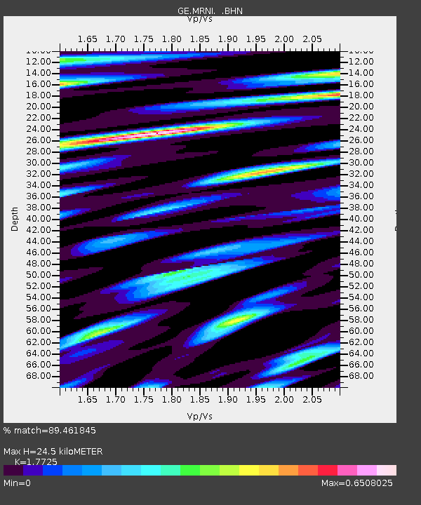
| Estimated Moho Depth: |
24.5 km |
| Estimated Crust Vp/Vs: |
1.77 |
| Assumed Crust Vp: |
5.738 km/s |
| Estimated Crust Vs: |
3.237 km/s |
| Estimated Crust Poisson's Ratio: |
0.27 |
|
| Radial Match: |
89.461845 % |
| Radial Bump: |
400 |
| Transverse Match: |
85.77105 % |
| Transverse Bump: |
400 |
| SOD ConfigId: |
3744 |
| Insert Time: |
2010-03-09 04:23:02.429 +0000 |
| GWidth: |
2.5 |
| Max Bumps: |
400 |
| Tol: |
0.001 |
|

Signal To Noise
| Channel | StoN | STA | LTA |
| GE:MRNI: :BHN:20000807T14:45:26.550015Z | 0.97758764 | 9.2012876E-8 | 9.4122385E-8 |
| GE:MRNI: :BHE:20000807T14:45:26.550015Z | 4.0192256 | 3.6865347E-7 | 9.172252E-8 |
| GE:MRNI: :BHZ:20000807T14:45:26.550015Z | 16.441328 | 2.2886056E-6 | 1.3919835E-7 |
| Arrivals |
| Ps | 3.4 SECOND |
| PpPs | 12 SECOND |
| PsPs/PpSs | 15 SECOND |


