You are here: Home > Network List > O2 - Oklahoma Consolidated Temporary Seismic Networks Stations List
> Station FW04 Hopeton, Oklahoma, USA > Earthquake Result Viewer
FW04 Hopeton, Oklahoma, USA - Earthquake Result Viewer
| Earthquake location: |
Off Coast Of Central Chile |
| Earthquake latitude/longitude: |
-39.3/-74.9 |
| Earthquake time(UTC): |
2020/12/27 (362) 21:39:15 GMT |
| Earthquake Depth: |
10 km |
| Earthquake Magnitude: |
6.7 mww |
| Earthquake Catalog/Contributor: |
NEIC PDE/us |
|
| Network: |
O2 Oklahoma Consolidated Temporary Seismic Networks |
| Station: |
FW04 Hopeton, Oklahoma, USA |
| Lat/Lon: |
36.60 N/98.67 W |
| Elevation: |
448 m |
|
| Distance: |
78.7 deg |
| Az: |
340.697 deg |
| Baz: |
161.428 deg |
| Ray Param: |
0.049482327 |
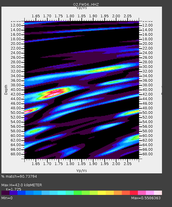
| Estimated Moho Depth: |
42.0 km |
| Estimated Crust Vp/Vs: |
1.73 |
| Assumed Crust Vp: |
6.426 km/s |
| Estimated Crust Vs: |
3.725 km/s |
| Estimated Crust Poisson's Ratio: |
0.25 |
|
| Radial Match: |
90.73794 % |
| Radial Bump: |
400 |
| Transverse Match: |
67.91064 % |
| Transverse Bump: |
400 |
| SOD ConfigId: |
23341671 |
| Insert Time: |
2021-01-10 22:57:15.742 +0000 |
| GWidth: |
2.5 |
| Max Bumps: |
400 |
| Tol: |
0.001 |
|

Signal To Noise
| Channel | StoN | STA | LTA |
| O2:FW04: :HHZ:20201227T21:50:46.360026Z | 35.02312 | 5.2667783E-6 | 1.5038003E-7 |
| O2:FW04: :HHN:20201227T21:50:46.360026Z | 6.958967 | 2.2721288E-6 | 3.2650374E-7 |
| O2:FW04: :HHE:20201227T21:50:46.360026Z | 2.7341616 | 1.2570889E-6 | 4.597713E-7 |
| Arrivals |
| Ps | 4.9 SECOND |
| PpPs | 17 SECOND |
| PsPs/PpSs | 22 SECOND |


