You are here: Home > Network List > O2 - Oklahoma Consolidated Temporary Seismic Networks Stations List
> Station SC14 Walters, Oklahoma, USA > Earthquake Result Viewer
SC14 Walters, Oklahoma, USA - Earthquake Result Viewer
| Earthquake location: |
Off Coast Of Central Chile |
| Earthquake latitude/longitude: |
-39.3/-74.9 |
| Earthquake time(UTC): |
2020/12/27 (362) 21:39:15 GMT |
| Earthquake Depth: |
10 km |
| Earthquake Magnitude: |
6.7 mww |
| Earthquake Catalog/Contributor: |
NEIC PDE/us |
|
| Network: |
O2 Oklahoma Consolidated Temporary Seismic Networks |
| Station: |
SC14 Walters, Oklahoma, USA |
| Lat/Lon: |
34.45 N/98.24 W |
| Elevation: |
339 m |
|
| Distance: |
76.5 deg |
| Az: |
340.336 deg |
| Baz: |
161.594 deg |
| Ray Param: |
0.0509337 |
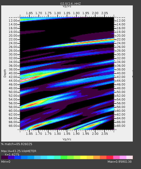
| Estimated Moho Depth: |
43.25 km |
| Estimated Crust Vp/Vs: |
1.63 |
| Assumed Crust Vp: |
6.315 km/s |
| Estimated Crust Vs: |
3.88 km/s |
| Estimated Crust Poisson's Ratio: |
0.20 |
|
| Radial Match: |
85.926025 % |
| Radial Bump: |
400 |
| Transverse Match: |
66.25712 % |
| Transverse Bump: |
400 |
| SOD ConfigId: |
23341671 |
| Insert Time: |
2021-01-10 22:58:11.063 +0000 |
| GWidth: |
2.5 |
| Max Bumps: |
400 |
| Tol: |
0.001 |
|

Signal To Noise
| Channel | StoN | STA | LTA |
| O2:SC14: :HHZ:20201227T21:50:34.465007Z | 20.365332 | 4.4192197E-6 | 2.169972E-7 |
| O2:SC14: :HHN:20201227T21:50:34.465007Z | 6.025625 | 2.170021E-6 | 3.6013208E-7 |
| O2:SC14: :HHE:20201227T21:50:34.465007Z | 3.551708 | 1.0679338E-6 | 3.0068176E-7 |
| Arrivals |
| Ps | 4.4 SECOND |
| PpPs | 17 SECOND |
| PsPs/PpSs | 22 SECOND |


