You are here: Home > Network List > GE - GEOFON Stations List
> Station MRNI GII Station Mount Meron, Israel > Earthquake Result Viewer
MRNI GII Station Mount Meron, Israel - Earthquake Result Viewer
| Earthquake location: |
Iceland |
| Earthquake latitude/longitude: |
64.0/-20.8 |
| Earthquake time(UTC): |
2000/06/21 (173) 00:51:46 GMT |
| Earthquake Depth: |
10 km |
| Earthquake Magnitude: |
6.1 MB, 6.6 MS, 6.5 MW, 6.4 MW |
| Earthquake Catalog/Contributor: |
WHDF/NEIC |
|
| Network: |
GE GEOFON |
| Station: |
MRNI GII Station Mount Meron, Israel |
| Lat/Lon: |
33.12 N/35.39 E |
| Elevation: |
918 m |
|
| Distance: |
46.0 deg |
| Az: |
104.457 deg |
| Baz: |
329.408 deg |
| Ray Param: |
0.070894 |
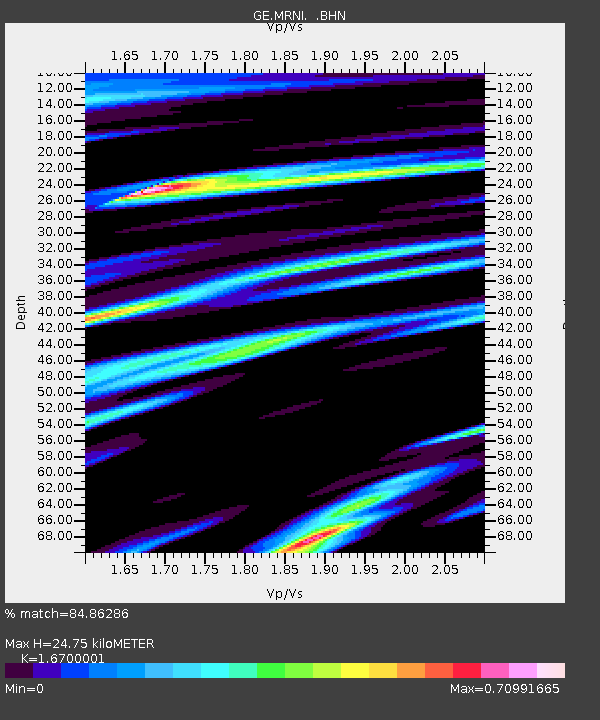
| Estimated Moho Depth: |
24.75 km |
| Estimated Crust Vp/Vs: |
1.67 |
| Assumed Crust Vp: |
5.738 km/s |
| Estimated Crust Vs: |
3.436 km/s |
| Estimated Crust Poisson's Ratio: |
0.22 |
|
| Radial Match: |
84.86286 % |
| Radial Bump: |
400 |
| Transverse Match: |
71.68181 % |
| Transverse Bump: |
400 |
| SOD ConfigId: |
3744 |
| Insert Time: |
2010-03-09 04:23:40.683 +0000 |
| GWidth: |
2.5 |
| Max Bumps: |
400 |
| Tol: |
0.001 |
|

Signal To Noise
| Channel | StoN | STA | LTA |
| GE:MRNI: :BHN:20000621T00:59:39.66299Z | 2.5836277 | 3.3657082E-7 | 1.3027064E-7 |
| GE:MRNI: :BHE:20000621T00:59:39.66299Z | 1.9243501 | 3.1186266E-7 | 1.620613E-7 |
| GE:MRNI: :BHZ:20000621T00:59:39.66299Z | 2.581759 | 7.9268017E-7 | 3.0703106E-7 |
| Arrivals |
| Ps | 3.0 SECOND |
| PpPs | 11 SECOND |
| PsPs/PpSs | 14 SECOND |


