You are here: Home > Network List > PR - Puerto Rico Seismic Network (PRSN) & Puerto Rico Strong Motion Program (PRSMP) Stations List
> Station CRPR Cabo Rojo, Puerto Rico(T3K97) > Earthquake Result Viewer
CRPR Cabo Rojo, Puerto Rico(T3K97) - Earthquake Result Viewer
| Earthquake location: |
Off Coast Of Central Chile |
| Earthquake latitude/longitude: |
-39.3/-74.9 |
| Earthquake time(UTC): |
2020/12/27 (362) 21:39:15 GMT |
| Earthquake Depth: |
10 km |
| Earthquake Magnitude: |
6.7 mww |
| Earthquake Catalog/Contributor: |
NEIC PDE/us |
|
| Network: |
PR Puerto Rico Seismic Network (PRSN) & Puerto Rico Strong Motion Program (PRSMP) |
| Station: |
CRPR Cabo Rojo, Puerto Rico(T3K97) |
| Lat/Lon: |
18.01 N/67.11 W |
| Elevation: |
65 m |
|
| Distance: |
57.5 deg |
| Az: |
8.811 deg |
| Baz: |
187.17 deg |
| Ray Param: |
0.063447215 |
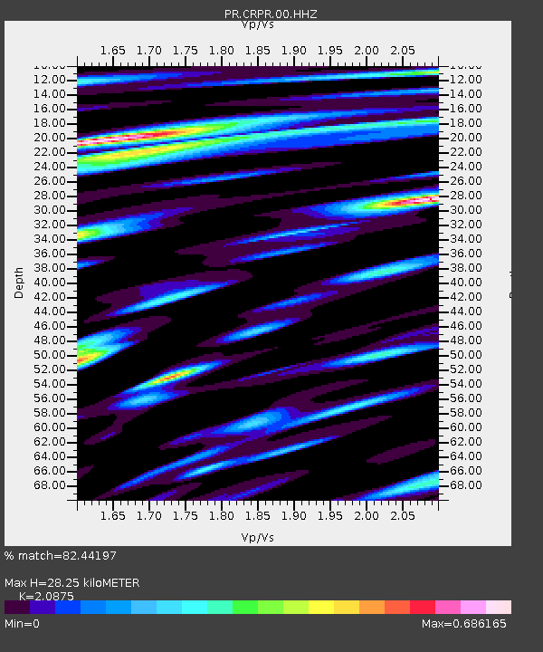
| Estimated Moho Depth: |
28.25 km |
| Estimated Crust Vp/Vs: |
2.09 |
| Assumed Crust Vp: |
5.14 km/s |
| Estimated Crust Vs: |
2.462 km/s |
| Estimated Crust Poisson's Ratio: |
0.35 |
|
| Radial Match: |
82.44197 % |
| Radial Bump: |
400 |
| Transverse Match: |
84.01005 % |
| Transverse Bump: |
400 |
| SOD ConfigId: |
23341671 |
| Insert Time: |
2021-01-10 23:00:40.075 +0000 |
| GWidth: |
2.5 |
| Max Bumps: |
400 |
| Tol: |
0.001 |
|

Signal To Noise
| Channel | StoN | STA | LTA |
| PR:CRPR:00:HHZ:20201227T21:48:33.850017Z | 31.719114 | 6.3581715E-6 | 2.0045236E-7 |
| PR:CRPR:00:HH1:20201227T21:48:33.850017Z | 7.432294 | 2.4477029E-6 | 3.2933343E-7 |
| PR:CRPR:00:HH2:20201227T21:48:33.850017Z | 2.3277001 | 5.8451894E-7 | 2.511144E-7 |
| Arrivals |
| Ps | 6.1 SECOND |
| PpPs | 17 SECOND |
| PsPs/PpSs | 23 SECOND |


