You are here: Home > Network List > GE - GEOFON Stations List
> Station MRNI GII Station Mount Meron, Israel > Earthquake Result Viewer
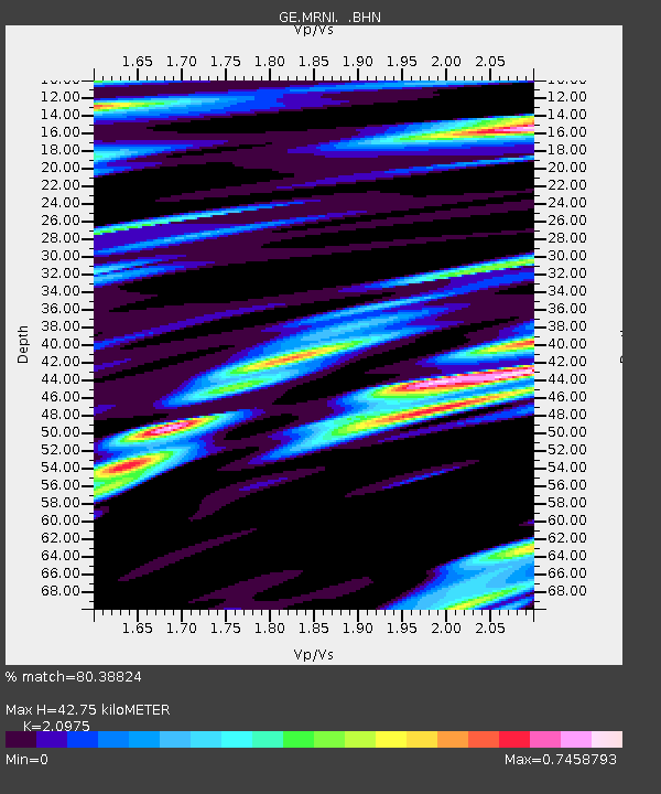
MRNI GII Station Mount Meron, Israel - Earthquake Result Viewer
| Earthquake location: |
Southeast Of Honshu, Japan |
| Earthquake latitude/longitude: |
30.5/137.7 |
| Earthquake time(UTC): |
2000/06/09 (161) 22:35:13 GMT |
| Earthquake Depth: |
473 km |
| Earthquake Magnitude: |
5.4 MB, 5.9 MW, 5.8 MW |
| Earthquake Catalog/Contributor: |
WHDF/NEIC |
|
| Network: |
GE GEOFON |
| Station: |
MRNI GII Station Mount Meron, Israel |
| Lat/Lon: |
33.12 N/35.39 E |
| Elevation: |
918 m |
|
| Distance: |
83.1 deg |
| Az: |
304.313 deg |
| Baz: |
58.182 deg |
| Ray Param: |
0.0450969 |
| Estimated Moho Depth: |
42.75 km |
| Estimated Crust Vp/Vs: |
2.10 |
| Assumed Crust Vp: |
5.738 km/s |
| Estimated Crust Vs: |
2.736 km/s |
| Estimated Crust Poisson's Ratio: |
0.35 |
|
| Radial Match: |
80.38824 % |
| Radial Bump: |
400 |
| Transverse Match: |
73.50867 % |
| Transverse Bump: |
400 |
| SOD ConfigId: |
3753 |
| Insert Time: |
2010-03-09 04:23:44.345 +0000 |
| GWidth: |
2.5 |
| Max Bumps: |
400 |
| Tol: |
0.001 |
|

Signal To Noise
| Channel | StoN | STA | LTA |
| GE:MRNI: :BHN:20000609T22:46:17.81302Z | 1.1158698 | 1.8900332E-7 | 1.6937757E-7 |
| GE:MRNI: :BHE:20000609T22:46:17.81302Z | 2.5027254 | 2.5902577E-7 | 1.03497484E-7 |
| GE:MRNI: :BHZ:20000609T22:46:17.81302Z | 14.48354 | 1.9590304E-6 | 1.352591E-7 |
| Arrivals |
| Ps | 8.3 SECOND |
| PpPs | 23 SECOND |
| PsPs/PpSs | 31 SECOND |


