You are here: Home > Network List > GE - GEOFON Stations List
> Station MRNI GII Station Mount Meron, Israel > Earthquake Result Viewer
MRNI GII Station Mount Meron, Israel - Earthquake Result Viewer
| Earthquake location: |
Taiwan Region |
| Earthquake latitude/longitude: |
24.0/122.7 |
| Earthquake time(UTC): |
2001/12/18 (352) 04:02:58 GMT |
| Earthquake Depth: |
14 km |
| Earthquake Magnitude: |
6.3 MB, 7.3 MS, 6.9 MW, 6.8 MW |
| Earthquake Catalog/Contributor: |
WHDF/NEIC |
|
| Network: |
GE GEOFON |
| Station: |
MRNI GII Station Mount Meron, Israel |
| Lat/Lon: |
33.12 N/35.39 E |
| Elevation: |
918 m |
|
| Distance: |
75.2 deg |
| Az: |
299.886 deg |
| Baz: |
70.94 deg |
| Ray Param: |
0.05180891 |
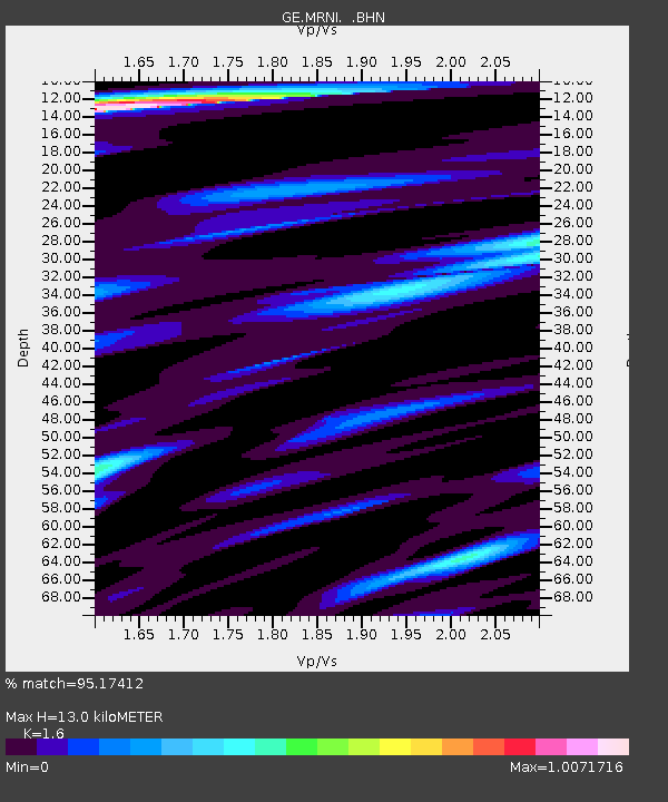
| Estimated Moho Depth: |
13.0 km |
| Estimated Crust Vp/Vs: |
1.60 |
| Assumed Crust Vp: |
5.738 km/s |
| Estimated Crust Vs: |
3.586 km/s |
| Estimated Crust Poisson's Ratio: |
0.18 |
|
| Radial Match: |
95.17412 % |
| Radial Bump: |
386 |
| Transverse Match: |
89.728935 % |
| Transverse Bump: |
400 |
| SOD ConfigId: |
20082 |
| Insert Time: |
2010-03-09 04:24:03.315 +0000 |
| GWidth: |
2.5 |
| Max Bumps: |
400 |
| Tol: |
0.001 |
|

Signal To Noise
| Channel | StoN | STA | LTA |
| GE:MRNI: :BHN:20011218T04:14:09.019014Z | 3.236066 | 3.9343948E-7 | 1.2157956E-7 |
| GE:MRNI: :BHE:20011218T04:14:09.019014Z | 0.98355955 | 1.4793281E-7 | 1.5040554E-7 |
| GE:MRNI: :BHZ:20011218T04:14:09.019014Z | 1.2424628 | 3.2471505E-7 | 2.613479E-7 |
| Arrivals |
| Ps | 1.4 SECOND |
| PpPs | 5.7 SECOND |
| PsPs/PpSs | 7.1 SECOND |


