You are here: Home > Network List > TX - Texas Seismological Network Stations List
> Station FW09 Farmers Branch > Earthquake Result Viewer
FW09 Farmers Branch - Earthquake Result Viewer
| Earthquake location: |
Off Coast Of Central Chile |
| Earthquake latitude/longitude: |
-39.3/-74.9 |
| Earthquake time(UTC): |
2020/12/27 (362) 21:39:15 GMT |
| Earthquake Depth: |
10 km |
| Earthquake Magnitude: |
6.7 mww |
| Earthquake Catalog/Contributor: |
NEIC PDE/us |
|
| Network: |
TX Texas Seismological Network |
| Station: |
FW09 Farmers Branch |
| Lat/Lon: |
32.92 N/96.91 W |
| Elevation: |
311 m |
|
| Distance: |
74.7 deg |
| Az: |
340.939 deg |
| Baz: |
162.478 deg |
| Ray Param: |
0.052131258 |
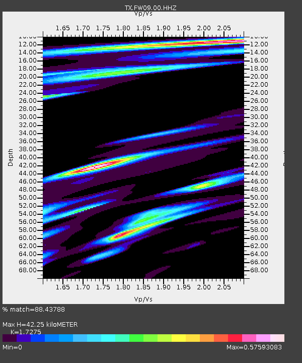
| Estimated Moho Depth: |
42.25 km |
| Estimated Crust Vp/Vs: |
1.73 |
| Assumed Crust Vp: |
6.38 km/s |
| Estimated Crust Vs: |
3.693 km/s |
| Estimated Crust Poisson's Ratio: |
0.25 |
|
| Radial Match: |
88.43788 % |
| Radial Bump: |
400 |
| Transverse Match: |
74.81031 % |
| Transverse Bump: |
400 |
| SOD ConfigId: |
23341671 |
| Insert Time: |
2021-01-10 23:03:02.022 +0000 |
| GWidth: |
2.5 |
| Max Bumps: |
400 |
| Tol: |
0.001 |
|

Signal To Noise
| Channel | StoN | STA | LTA |
| TX:FW09:00:HHZ:20201227T21:50:24.220012Z | 14.259641 | 6.253422E-6 | 4.3853993E-7 |
| TX:FW09:00:HH1:20201227T21:50:24.220012Z | 4.079503 | 1.9237468E-6 | 4.71564E-7 |
| TX:FW09:00:HH2:20201227T21:50:24.220012Z | 1.5021365 | 7.8477274E-7 | 5.224377E-7 |
| Arrivals |
| Ps | 5.0 SECOND |
| PpPs | 17 SECOND |
| PsPs/PpSs | 22 SECOND |


