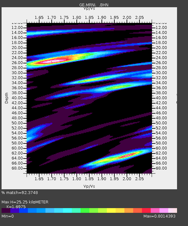
MRNI GII Station Mount Meron, Israel - Earthquake Result Viewer

Earthquake location: Andaman Islands, India Region
Earthquake latitude/longitude: 12.2/93.4
Earthquake time(UTC): 2001/08/05 (217) 05:16:16 GMT
Earthquake Depth: 96 km
Earthquake Magnitude: 5.4 MB, 5.2 MS, 6.0 MW, 5.9 MW
Earthquake Catalog/Contributor: WHDF/NEIC
Network: GE GEOFON
Station: MRNI GII Station Mount Meron, Israel
Lat/Lon: 33.12 N/35.39 E
Elevation: 918 m
Distance: 56.7 deg
Az: 301.618 deg
Baz: 97.253 deg
Ray Param: 0.063712716
Estimated Moho Depth: 25.25 km
Estimated Crust Vp/Vs: 1.70
Assumed Crust Vp: 5.738 km/s
Estimated Crust Vs: 3.38 km/s
Estimated Crust Poisson's Ratio: 0.23
Radial Match: 92.3748 %
Radial Bump: 400
Transverse Match: 75.45735 %
Transverse Bump: 400
SOD ConfigId: 20082
Insert Time: 2010-03-09 04:24:06.682 +0000
GWidth: 2.5
Max Bumps: 400
Tol: 0.001

Signal To Noise

ChannelStoNSTALTA
GE:MRNI: :BHN:20010805T05:25:19.491013Z0.9280928.2135074E-88.849885E-8
GE:MRNI: :BHE:20010805T05:25:19.491013Z1.56517591.1603144E-77.413316E-8
GE:MRNI: :BHZ:20010805T05:25:19.491013Z2.4610122.7629278E-71.12267955E-7
Arrivals
Ps3.2 SECOND
PpPs11 SECOND
PsPs/PpSs15 SECOND