You are here: Home > Network List > GE - GEOFON Stations List
> Station MRNI GII Station Mount Meron, Israel > Earthquake Result Viewer
MRNI GII Station Mount Meron, Israel - Earthquake Result Viewer
| Earthquake location: |
Southern India |
| Earthquake latitude/longitude: |
23.4/70.2 |
| Earthquake time(UTC): |
2001/01/26 (026) 03:16:40 GMT |
| Earthquake Depth: |
16 km |
| Earthquake Magnitude: |
6.9 MB, 8.0 MS, 7.7 MW, 7.7 ME |
| Earthquake Catalog/Contributor: |
WHDF/NEIC |
|
| Network: |
GE GEOFON |
| Station: |
MRNI GII Station Mount Meron, Israel |
| Lat/Lon: |
33.12 N/35.39 E |
| Elevation: |
918 m |
|
| Distance: |
32.0 deg |
| Az: |
295.366 deg |
| Baz: |
98.488 deg |
| Ray Param: |
0.07880686 |
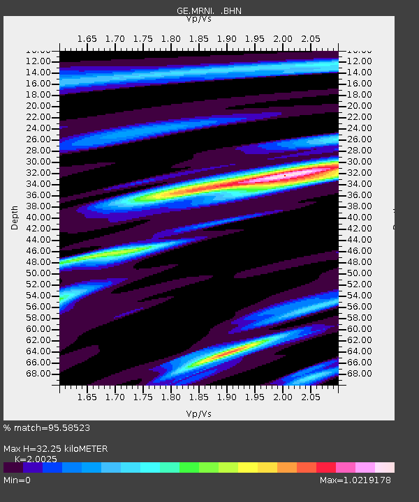
| Estimated Moho Depth: |
32.25 km |
| Estimated Crust Vp/Vs: |
2.00 |
| Assumed Crust Vp: |
5.738 km/s |
| Estimated Crust Vs: |
2.866 km/s |
| Estimated Crust Poisson's Ratio: |
0.33 |
|
| Radial Match: |
95.58523 % |
| Radial Bump: |
400 |
| Transverse Match: |
76.20924 % |
| Transverse Bump: |
400 |
| SOD ConfigId: |
3744 |
| Insert Time: |
2010-03-09 04:24:08.189 +0000 |
| GWidth: |
2.5 |
| Max Bumps: |
400 |
| Tol: |
0.001 |
|

Signal To Noise
| Channel | StoN | STA | LTA |
| GE:MRNI: :BHN:20010126T03:22:35.64801Z | 1.2578169 | 2.377801E-7 | 1.890419E-7 |
| GE:MRNI: :BHE:20010126T03:22:35.64801Z | 1.2048506 | 4.1586335E-7 | 3.4515762E-7 |
| GE:MRNI: :BHZ:20010126T03:22:35.64801Z | 2.1679232 | 9.1803054E-7 | 4.234608E-7 |
| Arrivals |
| Ps | 6.0 SECOND |
| PpPs | 16 SECOND |
| PsPs/PpSs | 22 SECOND |


