You are here: Home > Network List > TX - Texas Seismological Network Stations List
> Station MNHN Monahans > Earthquake Result Viewer
MNHN Monahans - Earthquake Result Viewer
| Earthquake location: |
Off Coast Of Central Chile |
| Earthquake latitude/longitude: |
-39.3/-74.9 |
| Earthquake time(UTC): |
2020/12/27 (362) 21:39:15 GMT |
| Earthquake Depth: |
10 km |
| Earthquake Magnitude: |
6.7 mww |
| Earthquake Catalog/Contributor: |
NEIC PDE/us |
|
| Network: |
TX Texas Seismological Network |
| Station: |
MNHN Monahans |
| Lat/Lon: |
31.34 N/102.76 W |
| Elevation: |
750 m |
|
| Distance: |
74.9 deg |
| Az: |
335.55 deg |
| Baz: |
157.971 deg |
| Ray Param: |
0.051994722 |
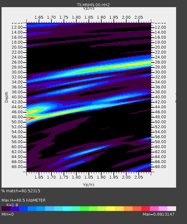
| Estimated Moho Depth: |
48.5 km |
| Estimated Crust Vp/Vs: |
1.60 |
| Assumed Crust Vp: |
6.121 km/s |
| Estimated Crust Vs: |
3.825 km/s |
| Estimated Crust Poisson's Ratio: |
0.18 |
|
| Radial Match: |
90.52315 % |
| Radial Bump: |
356 |
| Transverse Match: |
80.4426 % |
| Transverse Bump: |
400 |
| SOD ConfigId: |
23341671 |
| Insert Time: |
2021-01-10 23:03:23.737 +0000 |
| GWidth: |
2.5 |
| Max Bumps: |
400 |
| Tol: |
0.001 |
|

Signal To Noise
| Channel | StoN | STA | LTA |
| TX:MNHN:00:HHZ:20201227T21:50:25.345012Z | 19.813429 | 3.822969E-6 | 1.9294838E-7 |
| TX:MNHN:00:HH1:20201227T21:50:25.345012Z | 3.3030844 | 3.6089614E-7 | 1.0926034E-7 |
| TX:MNHN:00:HH2:20201227T21:50:25.345012Z | 9.885794 | 1.6119455E-6 | 1.6305675E-7 |
| Arrivals |
| Ps | 4.9 SECOND |
| PpPs | 20 SECOND |
| PsPs/PpSs | 25 SECOND |


