You are here: Home > Network List > GE - GEOFON Stations List
> Station MRNI GII Station Mount Meron, Israel > Earthquake Result Viewer
MRNI GII Station Mount Meron, Israel - Earthquake Result Viewer
| Earthquake location: |
Hokkaido, Japan Region |
| Earthquake latitude/longitude: |
43.1/145.9 |
| Earthquake time(UTC): |
2001/04/26 (116) 17:48:57 GMT |
| Earthquake Depth: |
86 km |
| Earthquake Magnitude: |
5.7 MB, 6.0 MW, 6.0 MW |
| Earthquake Catalog/Contributor: |
WHDF/NEIC |
|
| Network: |
GE GEOFON |
| Station: |
MRNI GII Station Mount Meron, Israel |
| Lat/Lon: |
33.12 N/35.39 E |
| Elevation: |
918 m |
|
| Distance: |
81.1 deg |
| Az: |
307.299 deg |
| Baz: |
43.972 deg |
| Ray Param: |
0.047634315 |
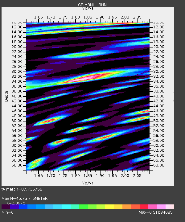
| Estimated Moho Depth: |
45.75 km |
| Estimated Crust Vp/Vs: |
2.10 |
| Assumed Crust Vp: |
5.738 km/s |
| Estimated Crust Vs: |
2.736 km/s |
| Estimated Crust Poisson's Ratio: |
0.35 |
|
| Radial Match: |
87.735756 % |
| Radial Bump: |
400 |
| Transverse Match: |
77.377144 % |
| Transverse Bump: |
400 |
| SOD ConfigId: |
4714 |
| Insert Time: |
2010-03-09 04:24:14.246 +0000 |
| GWidth: |
2.5 |
| Max Bumps: |
400 |
| Tol: |
0.001 |
|

Signal To Noise
| Channel | StoN | STA | LTA |
| GE:MRNI: :BHN:20010426T18:00:32.25302Z | 1.9080074 | 1.4272396E-7 | 7.480263E-8 |
| GE:MRNI: :BHE:20010426T18:00:32.25302Z | 1.0362725 | 1.2986044E-7 | 1.2531494E-7 |
| GE:MRNI: :BHZ:20010426T18:00:32.25302Z | 5.236561 | 8.9234635E-7 | 1.7040695E-7 |
| Arrivals |
| Ps | 8.9 SECOND |
| PpPs | 24 SECOND |
| PsPs/PpSs | 33 SECOND |


