You are here: Home > Network List > TX - Texas Seismological Network Stations List
> Station PH02 Texas Public Hunt System CROSS BAR MGT AREA > Earthquake Result Viewer
PH02 Texas Public Hunt System CROSS BAR MGT AREA - Earthquake Result Viewer
| Earthquake location: |
Off Coast Of Central Chile |
| Earthquake latitude/longitude: |
-39.3/-74.9 |
| Earthquake time(UTC): |
2020/12/27 (362) 21:39:15 GMT |
| Earthquake Depth: |
10 km |
| Earthquake Magnitude: |
6.7 mww |
| Earthquake Catalog/Contributor: |
NEIC PDE/us |
|
| Network: |
TX Texas Seismological Network |
| Station: |
PH02 Texas Public Hunt System CROSS BAR MGT AREA |
| Lat/Lon: |
35.39 N/101.95 W |
| Elevation: |
1022 m |
|
| Distance: |
78.4 deg |
| Az: |
337.726 deg |
| Baz: |
158.918 deg |
| Ray Param: |
0.049637545 |
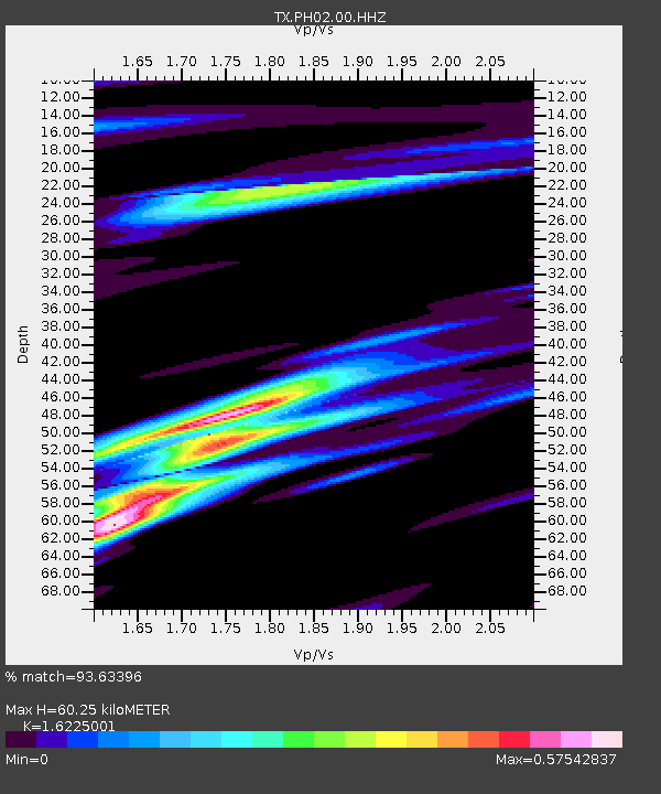
| Estimated Moho Depth: |
60.25 km |
| Estimated Crust Vp/Vs: |
1.62 |
| Assumed Crust Vp: |
6.426 km/s |
| Estimated Crust Vs: |
3.961 km/s |
| Estimated Crust Poisson's Ratio: |
0.19 |
|
| Radial Match: |
93.63396 % |
| Radial Bump: |
379 |
| Transverse Match: |
67.19951 % |
| Transverse Bump: |
400 |
| SOD ConfigId: |
23341671 |
| Insert Time: |
2021-01-10 23:03:54.537 +0000 |
| GWidth: |
2.5 |
| Max Bumps: |
400 |
| Tol: |
0.001 |
|

Signal To Noise
| Channel | StoN | STA | LTA |
| TX:PH02:00:HHZ:20201227T21:50:45.110026Z | 28.029564 | 5.144168E-6 | 1.8352651E-7 |
| TX:PH02:00:HH1:20201227T21:50:45.110026Z | 7.6472464 | 1.7778221E-6 | 2.3247874E-7 |
| TX:PH02:00:HH2:20201227T21:50:45.110026Z | 2.4381807 | 1.0725586E-6 | 4.3990116E-7 |
| Arrivals |
| Ps | 6.0 SECOND |
| PpPs | 24 SECOND |
| PsPs/PpSs | 30 SECOND |


