You are here: Home > Network List > US - United States National Seismic Network Stations List
> Station ACSO Alum Creek State Park, Ohio, USA > Earthquake Result Viewer
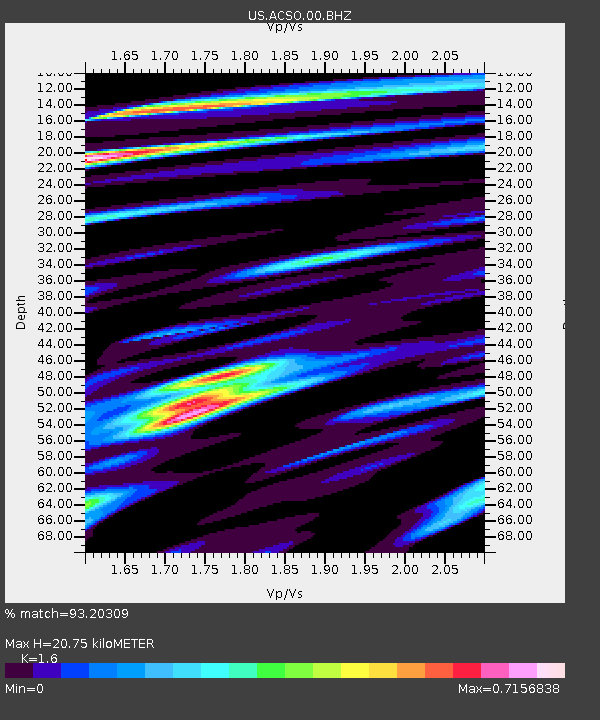
ACSO Alum Creek State Park, Ohio, USA - Earthquake Result Viewer
| Earthquake location: |
Off Coast Of Central Chile |
| Earthquake latitude/longitude: |
-39.3/-74.9 |
| Earthquake time(UTC): |
2020/12/27 (362) 21:39:15 GMT |
| Earthquake Depth: |
10 km |
| Earthquake Magnitude: |
6.7 mww |
| Earthquake Catalog/Contributor: |
NEIC PDE/us |
|
| Network: |
US United States National Seismic Network |
| Station: |
ACSO Alum Creek State Park, Ohio, USA |
| Lat/Lon: |
40.23 N/82.98 W |
| Elevation: |
288 m |
|
| Distance: |
79.5 deg |
| Az: |
353.727 deg |
| Baz: |
173.646 deg |
| Ray Param: |
0.048892453 |
| Estimated Moho Depth: |
20.75 km |
| Estimated Crust Vp/Vs: |
1.60 |
| Assumed Crust Vp: |
6.498 km/s |
| Estimated Crust Vs: |
4.061 km/s |
| Estimated Crust Poisson's Ratio: |
0.18 |
|
| Radial Match: |
93.20309 % |
| Radial Bump: |
400 |
| Transverse Match: |
91.10569 % |
| Transverse Bump: |
400 |
| SOD ConfigId: |
23341671 |
| Insert Time: |
2021-01-10 23:05:03.365 +0000 |
| GWidth: |
2.5 |
| Max Bumps: |
400 |
| Tol: |
0.001 |
|

Signal To Noise
| Channel | StoN | STA | LTA |
| US:ACSO:00:BHZ:20201227T21:50:51.098979Z | 12.457039 | 9.3865765E-7 | 7.5351586E-8 |
| US:ACSO:00:BH1:20201227T21:50:51.098979Z | 3.0227342 | 3.9881886E-7 | 1.3193977E-7 |
| US:ACSO:00:BH2:20201227T21:50:51.098979Z | 1.2367058 | 1.942602E-7 | 1.5707874E-7 |
| Arrivals |
| Ps | 2.0 SECOND |
| PpPs | 8.0 SECOND |
| PsPs/PpSs | 10 SECOND |


