You are here: Home > Network List > US - United States National Seismic Network Stations List
> Station AMTX Amarillo, Texas, USA > Earthquake Result Viewer
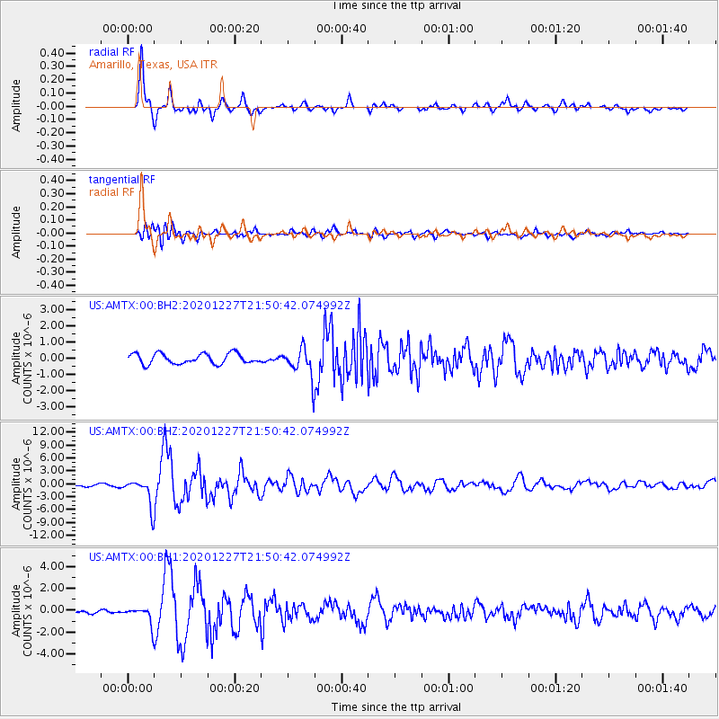
AMTX Amarillo, Texas, USA - Earthquake Result Viewer
*The percent match for this event was below the threshold and hence no stack was calculated.
| Earthquake location: |
Off Coast Of Central Chile |
| Earthquake latitude/longitude: |
-39.3/-74.9 |
| Earthquake time(UTC): |
2020/12/27 (362) 21:39:15 GMT |
| Earthquake Depth: |
10 km |
| Earthquake Magnitude: |
6.7 mww |
| Earthquake Catalog/Contributor: |
NEIC PDE/us |
|
| Network: |
US United States National Seismic Network |
| Station: |
AMTX Amarillo, Texas, USA |
| Lat/Lon: |
34.53 N/101.41 W |
| Elevation: |
1010 m |
|
| Distance: |
77.5 deg |
| Az: |
337.835 deg |
| Baz: |
159.248 deg |
| Ray Param: |
$rayparam |
*The percent match for this event was below the threshold and hence was not used in the summary stack. |
|
| Radial Match: |
95.07972 % |
| Radial Bump: |
311 |
| Transverse Match: |
80.93003 % |
| Transverse Bump: |
400 |
| SOD ConfigId: |
23341671 |
| Insert Time: |
2021-01-10 23:05:06.794 +0000 |
| GWidth: |
2.5 |
| Max Bumps: |
400 |
| Tol: |
0.001 |
|
Signal To Noise
| Channel | StoN | STA | LTA |
| US:AMTX:00:BHZ:20201227T21:50:42.074992Z | 9.103928 | 3.3517977E-6 | 3.6817048E-7 |
| US:AMTX:00:BH1:20201227T21:50:42.074992Z | 3.3981912 | 8.408421E-7 | 2.4743815E-7 |
| US:AMTX:00:BH2:20201227T21:50:42.074992Z | 1.1508034 | 3.7644986E-7 | 3.2711915E-7 |
| Arrivals |
| Ps | |
| PpPs | |
| PsPs/PpSs | |


