You are here: Home > Network List > IW - Intermountain West Stations List
> Station IMW Indian Meadow, Wyoming, USA > Earthquake Result Viewer
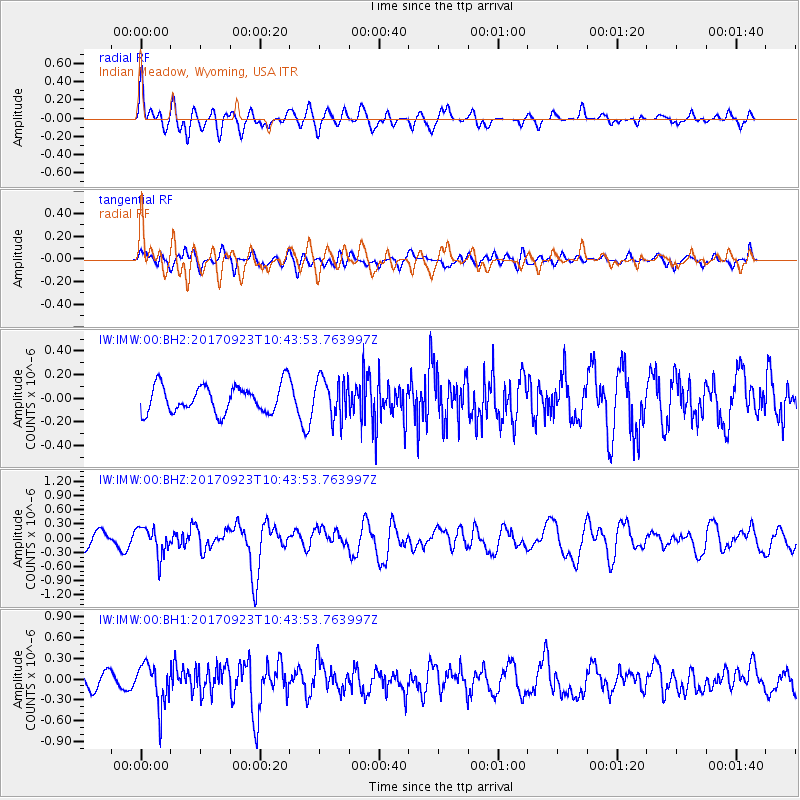
IMW Indian Meadow, Wyoming, USA - Earthquake Result Viewer
*The percent match for this event was below the threshold and hence no stack was calculated.
| Earthquake location: |
Near Coast Of Oaxaca, Mexico |
| Earthquake latitude/longitude: |
15.7/-94.2 |
| Earthquake time(UTC): |
2017/09/23 (266) 10:38:08 GMT |
| Earthquake Depth: |
74 km |
| Earthquake Magnitude: |
5.8 Mww |
| Earthquake Catalog/Contributor: |
NEIC PDE/us |
|
| Network: |
IW Intermountain West |
| Station: |
IMW Indian Meadow, Wyoming, USA |
| Lat/Lon: |
43.90 N/110.94 W |
| Elevation: |
2646 m |
|
| Distance: |
31.5 deg |
| Az: |
336.478 deg |
| Baz: |
147.877 deg |
| Ray Param: |
$rayparam |
*The percent match for this event was below the threshold and hence was not used in the summary stack. |
|
| Radial Match: |
70.7244 % |
| Radial Bump: |
400 |
| Transverse Match: |
59.224445 % |
| Transverse Bump: |
400 |
| SOD ConfigId: |
2364251 |
| Insert Time: |
2017-10-09 20:41:47.321 +0000 |
| GWidth: |
2.5 |
| Max Bumps: |
400 |
| Tol: |
0.001 |
|
Signal To Noise
| Channel | StoN | STA | LTA |
| IW:IMW:00:BHZ:20170923T10:43:53.763997Z | 2.2979395 | 2.9679376E-7 | 1.2915646E-7 |
| IW:IMW:00:BH1:20170923T10:43:53.763997Z | 2.3923936 | 3.009363E-7 | 1.257888E-7 |
| IW:IMW:00:BH2:20170923T10:43:53.763997Z | 1.4360482 | 1.6757986E-7 | 1.16695155E-7 |
| Arrivals |
| Ps | |
| PpPs | |
| PsPs/PpSs | |


