You are here: Home > Network List > GE - GEOFON Stations List
> Station CSS GEOFON/GII Station Mathiatis, Cyprus > Earthquake Result Viewer
CSS GEOFON/GII Station Mathiatis, Cyprus - Earthquake Result Viewer
| Earthquake location: |
Ryukyu Islands, Japan |
| Earthquake latitude/longitude: |
28.6/129.9 |
| Earthquake time(UTC): |
2006/11/17 (321) 18:03:12 GMT |
| Earthquake Depth: |
22 km |
| Earthquake Magnitude: |
5.8 MB, 5.8 MS, 6.2 MW, 6.1 MW |
| Earthquake Catalog/Contributor: |
WHDF/NEIC |
|
| Network: |
GE GEOFON |
| Station: |
CSS GEOFON/GII Station Mathiatis, Cyprus |
| Lat/Lon: |
34.96 N/33.33 E |
| Elevation: |
396 m |
|
| Distance: |
79.1 deg |
| Az: |
303.805 deg |
| Baz: |
62.832 deg |
| Ray Param: |
0.049166266 |
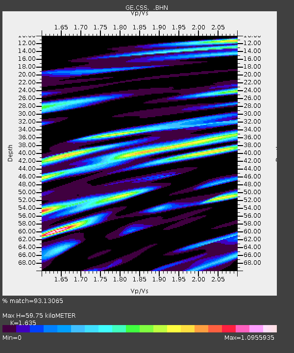
| Estimated Moho Depth: |
59.75 km |
| Estimated Crust Vp/Vs: |
1.63 |
| Assumed Crust Vp: |
5.782 km/s |
| Estimated Crust Vs: |
3.537 km/s |
| Estimated Crust Poisson's Ratio: |
0.20 |
|
| Radial Match: |
93.13065 % |
| Radial Bump: |
400 |
| Transverse Match: |
95.02473 % |
| Transverse Bump: |
400 |
| SOD ConfigId: |
2564 |
| Insert Time: |
2010-03-09 04:24:54.590 +0000 |
| GWidth: |
2.5 |
| Max Bumps: |
400 |
| Tol: |
0.001 |
|

Signal To Noise
| Channel | StoN | STA | LTA |
| GE:CSS: :BHN:20061117T18:14:43.629019Z | 3.4601974 | 2.1219287E-7 | 6.1323924E-8 |
| GE:CSS: :BHE:20061117T18:14:43.629019Z | 9.417499 | 3.768592E-7 | 4.0016907E-8 |
| GE:CSS: :BHZ:20061117T18:14:43.629019Z | 16.034779 | 8.165663E-7 | 5.0924697E-8 |
| Arrivals |
| Ps | 6.7 SECOND |
| PpPs | 27 SECOND |
| PsPs/PpSs | 33 SECOND |


