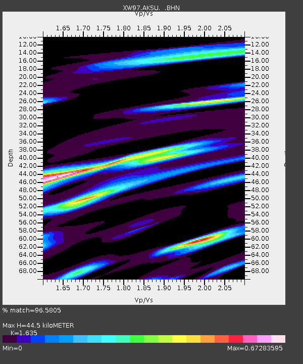
AKSU XW.AKSU - Earthquake Result Viewer

Earthquake location: Southeast Of Shikoku, Japan
Earthquake latitude/longitude: 29.4/132.1
Earthquake time(UTC): 2000/06/15 (167) 11:10:46 GMT
Earthquake Depth: 10 km
Earthquake Magnitude: 6.0 MB, 5.6 MS, 6.1 MW, 6.1 MW
Earthquake Catalog/Contributor: WHDF/NEIC
Network: XW Tien Shan Continental Dynamics
Station: AKSU XW.AKSU
Lat/Lon: 41.14 N/80.11 E
Elevation: 1109 m
Distance: 43.5 deg
Az: 300.119 deg
Baz: 88.664 deg
Ray Param: 0.07254221
Estimated Moho Depth: 44.5 km
Estimated Crust Vp/Vs: 1.63
Assumed Crust Vp: 6.129 km/s
Estimated Crust Vs: 3.749 km/s
Estimated Crust Poisson's Ratio: 0.20
Radial Match: 96.5805 %
Radial Bump: 366
Transverse Match: 83.41238 %
Transverse Bump: 400
SOD ConfigId: 20082
Insert Time: 2010-02-26 15:13:55.029 +0000
GWidth: 2.5
Max Bumps: 400
Tol: 0.001

Signal To Noise

ChannelStoNSTALTA
XW:AKSU: :BHN:20000615T11:18:18.400002Z1.01922074.3577458E-84.2755666E-8
XW:AKSU: :BHE:20000615T11:18:18.400002Z18.7732225.4911544E-72.924993E-8
XW:AKSU: :BHZ:20000615T11:18:18.400002Z13.2224648.6289464E-76.525975E-8
Arrivals
Ps4.9 SECOND
PpPs18 SECOND
PsPs/PpSs23 SECOND