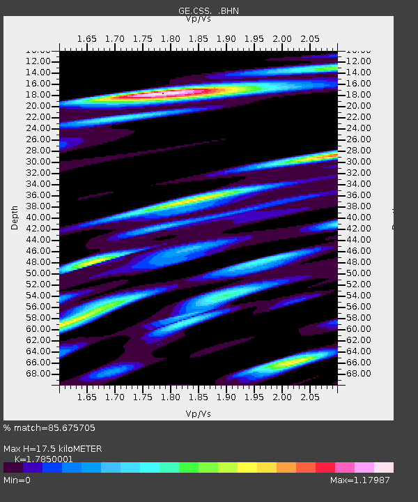
CSS GEOFON/GII Station Mathiatis, Cyprus - Earthquake Result Viewer

Earthquake location: Northern Sumatra, Indonesia
Earthquake latitude/longitude: 1.7/97.1
Earthquake time(UTC): 2006/07/27 (208) 11:16:40 GMT
Earthquake Depth: 20 km
Earthquake Magnitude: 5.6 MB, 6.1 MS, 6.1 MW, 6.0 MW
Earthquake Catalog/Contributor: WHDF/NEIC
Network: GE GEOFON
Station: CSS GEOFON/GII Station Mathiatis, Cyprus
Lat/Lon: 34.96 N/33.33 E
Elevation: 396 m
Distance: 67.7 deg
Az: 307.2 deg
Baz: 104.22 deg
Ray Param: 0.05675294
Estimated Moho Depth: 17.5 km
Estimated Crust Vp/Vs: 1.79
Assumed Crust Vp: 5.782 km/s
Estimated Crust Vs: 3.239 km/s
Estimated Crust Poisson's Ratio: 0.27
Radial Match: 85.675705 %
Radial Bump: 400
Transverse Match: 82.278244 %
Transverse Bump: 400
SOD ConfigId: 2665
Insert Time: 2010-03-09 04:25:26.183 +0000
GWidth: 2.5
Max Bumps: 400
Tol: 0.001

Signal To Noise

ChannelStoNSTALTA
GE:CSS: :BHN:20060727T11:27:05.179021Z1.20086291.542332E-71.2843532E-7
GE:CSS: :BHE:20060727T11:27:05.179021Z3.78023173.30424E-78.7408395E-8
GE:CSS: :BHZ:20060727T11:27:05.179021Z6.8586835.505348E-78.02683E-8
Arrivals
Ps2.5 SECOND
PpPs8.2 SECOND
PsPs/PpSs11 SECOND