You are here: Home > Network List > C0 - Colorado Geological Survey Seismic Network Stations List
> Station T25A Trinidad, CO > Earthquake Result Viewer
T25A Trinidad, CO - Earthquake Result Viewer
| Earthquake location: |
Northwestern Balkan Region |
| Earthquake latitude/longitude: |
45.4/16.3 |
| Earthquake time(UTC): |
2020/12/29 (364) 11:19:54 GMT |
| Earthquake Depth: |
10 km |
| Earthquake Magnitude: |
6.4 mww |
| Earthquake Catalog/Contributor: |
NEIC PDE/us |
|
| Network: |
C0 Colorado Geological Survey Seismic Network |
| Station: |
T25A Trinidad, CO |
| Lat/Lon: |
37.08 N/104.25 W |
| Elevation: |
1800 m |
|
| Distance: |
82.0 deg |
| Az: |
315.927 deg |
| Baz: |
37.783 deg |
| Ray Param: |
0.047223337 |
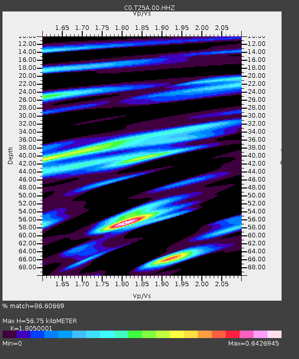
| Estimated Moho Depth: |
56.75 km |
| Estimated Crust Vp/Vs: |
1.81 |
| Assumed Crust Vp: |
6.316 km/s |
| Estimated Crust Vs: |
3.499 km/s |
| Estimated Crust Poisson's Ratio: |
0.28 |
|
| Radial Match: |
86.60669 % |
| Radial Bump: |
356 |
| Transverse Match: |
61.914955 % |
| Transverse Bump: |
400 |
| SOD ConfigId: |
23341671 |
| Insert Time: |
2021-01-12 12:25:07.009 +0000 |
| GWidth: |
2.5 |
| Max Bumps: |
400 |
| Tol: |
0.001 |
|

Signal To Noise
| Channel | StoN | STA | LTA |
| C0:T25A:00:HHZ:20201229T11:31:43.469009Z | 1.7494692 | 2.4803998E-7 | 1.4178015E-7 |
| C0:T25A:00:HHN:20201229T11:31:43.469009Z | 0.95095986 | 1.4682436E-7 | 1.5439596E-7 |
| C0:T25A:00:HHE:20201229T11:31:43.469009Z | 2.305315 | 2.9024906E-7 | 1.2590428E-7 |
| Arrivals |
| Ps | 7.4 SECOND |
| PpPs | 25 SECOND |
| PsPs/PpSs | 32 SECOND |


