You are here: Home > Network List > CN - Canadian National Seismograph Network Stations List
> Station BLKN Baker Lake, NU, CA > Earthquake Result Viewer
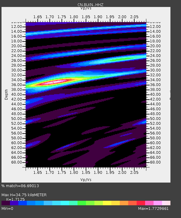
BLKN Baker Lake, NU, CA - Earthquake Result Viewer
| Earthquake location: |
Northwestern Balkan Region |
| Earthquake latitude/longitude: |
45.4/16.3 |
| Earthquake time(UTC): |
2020/12/29 (364) 11:19:54 GMT |
| Earthquake Depth: |
10 km |
| Earthquake Magnitude: |
6.4 mww |
| Earthquake Catalog/Contributor: |
NEIC PDE/us |
|
| Network: |
CN Canadian National Seismograph Network |
| Station: |
BLKN Baker Lake, NU, CA |
| Lat/Lon: |
64.32 N/96.00 W |
| Elevation: |
40 m |
|
| Distance: |
58.5 deg |
| Az: |
331.784 deg |
| Baz: |
49.845 deg |
| Ray Param: |
0.06279123 |
| Estimated Moho Depth: |
34.75 km |
| Estimated Crust Vp/Vs: |
1.71 |
| Assumed Crust Vp: |
6.459 km/s |
| Estimated Crust Vs: |
3.772 km/s |
| Estimated Crust Poisson's Ratio: |
0.24 |
|
| Radial Match: |
86.69013 % |
| Radial Bump: |
374 |
| Transverse Match: |
54.545586 % |
| Transverse Bump: |
400 |
| SOD ConfigId: |
23341671 |
| Insert Time: |
2021-01-12 12:26:55.342 +0000 |
| GWidth: |
2.5 |
| Max Bumps: |
400 |
| Tol: |
0.001 |
|

Signal To Noise
| Channel | StoN | STA | LTA |
| CN:BLKN: :HHZ:20201229T11:29:20.079971Z | 4.674023 | 9.045943E-7 | 1.9353654E-7 |
| CN:BLKN: :HHN:20201229T11:29:20.079971Z | 1.4878895 | 2.7726816E-7 | 1.8634995E-7 |
| CN:BLKN: :HHE:20201229T11:29:20.079971Z | 3.5818264 | 4.236871E-7 | 1.1828801E-7 |
| Arrivals |
| Ps | 4.0 SECOND |
| PpPs | 14 SECOND |
| PsPs/PpSs | 18 SECOND |


