You are here: Home > Network List > CN - Canadian National Seismograph Network Stations List
> Station INK INUVIK, NT > Earthquake Result Viewer
INK INUVIK, NT - Earthquake Result Viewer
*The percent match for this event was below the threshold and hence no stack was calculated.
| Earthquake location: |
Northwestern Balkan Region |
| Earthquake latitude/longitude: |
45.4/16.3 |
| Earthquake time(UTC): |
2020/12/29 (364) 11:19:54 GMT |
| Earthquake Depth: |
10 km |
| Earthquake Magnitude: |
6.4 mww |
| Earthquake Catalog/Contributor: |
NEIC PDE/us |
|
| Network: |
CN Canadian National Seismograph Network |
| Station: |
INK INUVIK, NT |
| Lat/Lon: |
68.31 N/133.53 W |
| Elevation: |
44 m |
|
| Distance: |
64.4 deg |
| Az: |
348.037 deg |
| Baz: |
23.123 deg |
| Ray Param: |
$rayparam |
*The percent match for this event was below the threshold and hence was not used in the summary stack. |
|
| Radial Match: |
75.66387 % |
| Radial Bump: |
400 |
| Transverse Match: |
50.701797 % |
| Transverse Bump: |
400 |
| SOD ConfigId: |
23341671 |
| Insert Time: |
2021-01-12 12:27:35.327 +0000 |
| GWidth: |
2.5 |
| Max Bumps: |
400 |
| Tol: |
0.001 |
|
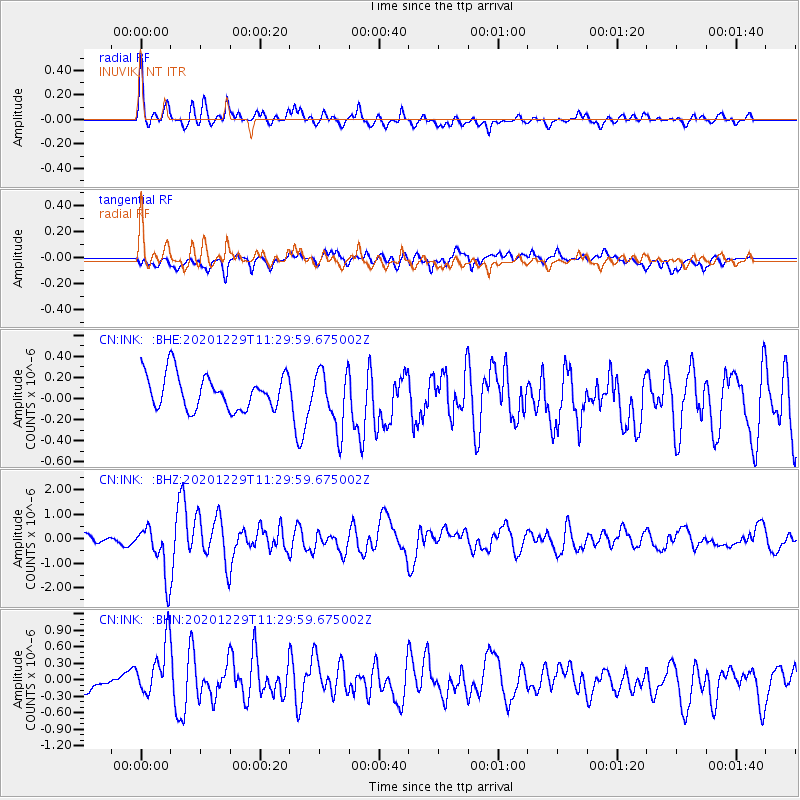
Signal To Noise
| Channel | StoN | STA | LTA |
| CN:INK: :BHZ:20201229T11:29:59.675002Z | 4.7149267 | 1.0672572E-6 | 2.2635712E-7 |
| CN:INK: :BHN:20201229T11:29:59.675002Z | 2.6672113 | 5.8780023E-7 | 2.2038006E-7 |
| CN:INK: :BHE:20201229T11:29:59.675002Z | 1.7003514 | 2.788029E-7 | 1.6396783E-7 |
| Arrivals |
| Ps | |
| PpPs | |
| PsPs/PpSs | |


