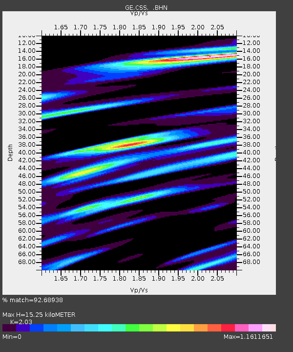
CSS GEOFON/GII Station Mathiatis, Cyprus - Earthquake Result Viewer

Earthquake location: Southern Sumatra, Indonesia
Earthquake latitude/longitude: -4.7/102.1
Earthquake time(UTC): 2000/06/04 (156) 16:28:26 GMT
Earthquake Depth: 33 km
Earthquake Magnitude: 6.8 MB, 8.0 MS, 7.9 MW, 7.7 MW
Earthquake Catalog/Contributor: WHDF/NEIC
Network: GE GEOFON
Station: CSS GEOFON/GII Station Mathiatis, Cyprus
Lat/Lon: 34.96 N/33.33 E
Elevation: 396 m
Distance: 75.5 deg
Az: 307.756 deg
Baz: 106.386 deg
Ray Param: 0.05156345
Estimated Moho Depth: 15.25 km
Estimated Crust Vp/Vs: 2.03
Assumed Crust Vp: 5.782 km/s
Estimated Crust Vs: 2.848 km/s
Estimated Crust Poisson's Ratio: 0.34
Radial Match: 92.68938 %
Radial Bump: 400
Transverse Match: 93.822845 %
Transverse Bump: 400
SOD ConfigId: 3744
Insert Time: 2010-03-09 04:26:39.070 +0000
GWidth: 2.5
Max Bumps: 400
Tol: 0.001

Signal To Noise

ChannelStoNSTALTA
GE:CSS: :BHN:20000604T16:39:36.261003Z1.32430161.04124034E-77.8625625E-8
GE:CSS: :BHE:20000604T16:39:36.261003Z2.12615682.0372084E-79.581647E-8
GE:CSS: :BHZ:20000604T16:39:36.261003Z2.735983.4694213E-71.2680725E-7
Arrivals
Ps2.8 SECOND
PpPs7.8 SECOND
PsPs/PpSs11 SECOND