You are here: Home > Network List > GS - US Geological Survey Networks Stations List
> Station MT03 Stemple Pass Rd, Helena Natl Forest, Montana, USA > Earthquake Result Viewer
MT03 Stemple Pass Rd, Helena Natl Forest, Montana, USA - Earthquake Result Viewer

| Earthquake location: |
Oaxaca, Mexico |
| Earthquake latitude/longitude: |
16.7/-94.9 |
| Earthquake time(UTC): |
2017/09/23 (266) 12:53:02 GMT |
| Earthquake Depth: |
9.1 km |
| Earthquake Magnitude: |
6.1 Mww |
| Earthquake Catalog/Contributor: |
NEIC PDE/us |
|
| Network: |
GS US Geological Survey Networks |
| Station: |
MT03 Stemple Pass Rd, Helena Natl Forest, Montana, USA |
| Lat/Lon: |
46.91 N/112.50 W |
| Elevation: |
2025 m |
|
| Distance: |
33.4 deg |
| Az: |
337.946 deg |
| Baz: |
148.348 deg |
| Ray Param: |
0.07822237 |
| Estimated Moho Depth: |
46.0 km |
| Estimated Crust Vp/Vs: |
1.61 |
| Assumed Crust Vp: |
6.353 km/s |
| Estimated Crust Vs: |
3.958 km/s |
| Estimated Crust Poisson's Ratio: |
0.18 |
|
| Radial Match: |
85.70493 % |
| Radial Bump: |
400 |
| Transverse Match: |
64.2956 % |
| Transverse Bump: |
400 |
| SOD ConfigId: |
2364251 |
| Insert Time: |
2017-10-09 20:44:11.660 +0000 |
| GWidth: |
2.5 |
| Max Bumps: |
400 |
| Tol: |
0.001 |
|
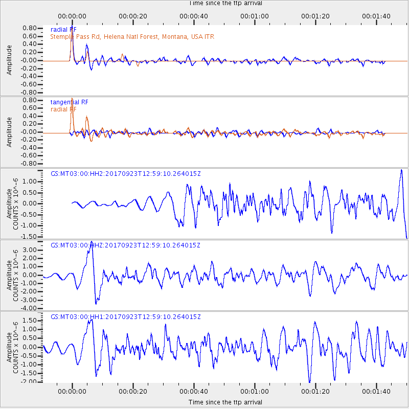
Signal To Noise
| Channel | StoN | STA | LTA |
| GS:MT03:00:HHZ:20170923T12:59:10.264015Z | 7.6384163 | 9.2949284E-7 | 1.216866E-7 |
| GS:MT03:00:HH1:20170923T12:59:10.264015Z | 4.3674645 | 5.7490047E-7 | 1.3163255E-7 |
| GS:MT03:00:HH2:20170923T12:59:10.264015Z | 3.8785603 | 4.2093467E-7 | 1.0852858E-7 |
| Arrivals |
| Ps | 4.8 SECOND |
| PpPs | 17 SECOND |
| PsPs/PpSs | 22 SECOND |


