You are here: Home > Network List > LM - Michigan State University Seismic Network Stations List
> Station L48A N Adams, MI, USA > Earthquake Result Viewer
L48A N Adams, MI, USA - Earthquake Result Viewer
| Earthquake location: |
Northwestern Balkan Region |
| Earthquake latitude/longitude: |
45.4/16.3 |
| Earthquake time(UTC): |
2020/12/29 (364) 11:19:54 GMT |
| Earthquake Depth: |
10 km |
| Earthquake Magnitude: |
6.4 mww |
| Earthquake Catalog/Contributor: |
NEIC PDE/us |
|
| Network: |
LM Michigan State University Seismic Network |
| Station: |
L48A N Adams, MI, USA |
| Lat/Lon: |
41.94 N/84.43 W |
| Elevation: |
369 m |
|
| Distance: |
68.0 deg |
| Az: |
307.756 deg |
| Baz: |
48.288 deg |
| Ray Param: |
0.05660357 |
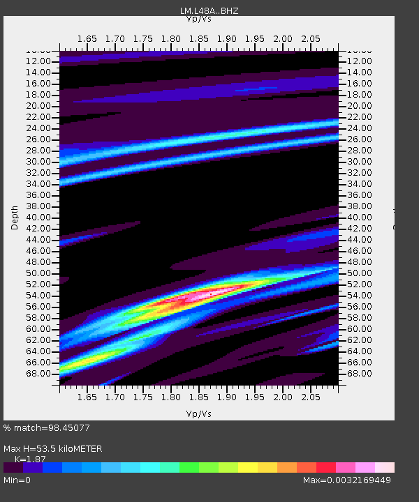
| Estimated Moho Depth: |
53.5 km |
| Estimated Crust Vp/Vs: |
1.87 |
| Assumed Crust Vp: |
6.498 km/s |
| Estimated Crust Vs: |
3.475 km/s |
| Estimated Crust Poisson's Ratio: |
0.30 |
|
| Radial Match: |
98.45077 % |
| Radial Bump: |
74 |
| Transverse Match: |
97.92429 % |
| Transverse Bump: |
132 |
| SOD ConfigId: |
23341671 |
| Insert Time: |
2021-01-12 12:32:18.947 +0000 |
| GWidth: |
2.5 |
| Max Bumps: |
400 |
| Tol: |
0.001 |
|

Signal To Noise
| Channel | StoN | STA | LTA |
| LM:L48A: :BHZ:20201229T11:30:22.823989Z | 0.8320701 | 8.866079E-6 | 1.0655448E-5 |
| LM:L48A: :BHN:20201229T11:30:22.823989Z | 0.8975712 | 1.2648886E-7 | 1.4092348E-7 |
| LM:L48A: :BHE:20201229T11:30:22.823989Z | 0.91015136 | 9.695069E-8 | 1.06521505E-7 |
| Arrivals |
| Ps | 7.4 SECOND |
| PpPs | 23 SECOND |
| PsPs/PpSs | 30 SECOND |


