You are here: Home > Network List > N4 - Central and EAstern US Network Stations List
> Station N38B Corydon, IA, USA > Earthquake Result Viewer
N38B Corydon, IA, USA - Earthquake Result Viewer
| Earthquake location: |
Northwestern Balkan Region |
| Earthquake latitude/longitude: |
45.4/16.3 |
| Earthquake time(UTC): |
2020/12/29 (364) 11:19:54 GMT |
| Earthquake Depth: |
10 km |
| Earthquake Magnitude: |
6.4 mww |
| Earthquake Catalog/Contributor: |
NEIC PDE/us |
|
| Network: |
N4 Central and EAstern US Network |
| Station: |
N38B Corydon, IA, USA |
| Lat/Lon: |
40.79 N/93.24 W |
| Elevation: |
322 m |
|
| Distance: |
73.6 deg |
| Az: |
311.748 deg |
| Baz: |
43.803 deg |
| Ray Param: |
0.052930553 |
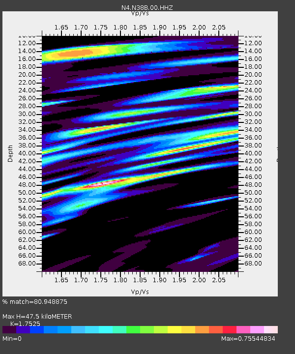
| Estimated Moho Depth: |
47.5 km |
| Estimated Crust Vp/Vs: |
1.75 |
| Assumed Crust Vp: |
6.498 km/s |
| Estimated Crust Vs: |
3.708 km/s |
| Estimated Crust Poisson's Ratio: |
0.26 |
|
| Radial Match: |
80.948875 % |
| Radial Bump: |
400 |
| Transverse Match: |
58.005283 % |
| Transverse Bump: |
400 |
| SOD ConfigId: |
23341671 |
| Insert Time: |
2021-01-12 12:34:04.081 +0000 |
| GWidth: |
2.5 |
| Max Bumps: |
400 |
| Tol: |
0.001 |
|

Signal To Noise
| Channel | StoN | STA | LTA |
| N4:N38B:00:HHZ:20201229T11:30:56.58998Z | 6.388472 | 8.7557396E-7 | 1.370553E-7 |
| N4:N38B:00:HH1:20201229T11:30:56.58998Z | 2.3610764 | 3.3803082E-7 | 1.4316811E-7 |
| N4:N38B:00:HH2:20201229T11:30:56.58998Z | 2.3410757 | 4.312305E-7 | 1.8420187E-7 |
| Arrivals |
| Ps | 5.7 SECOND |
| PpPs | 19 SECOND |
| PsPs/PpSs | 25 SECOND |


