You are here: Home > Network List > N4 - Central and EAstern US Network Stations List
> Station P53A Whipple, OH, USA > Earthquake Result Viewer
P53A Whipple, OH, USA - Earthquake Result Viewer
| Earthquake location: |
Northwestern Balkan Region |
| Earthquake latitude/longitude: |
45.4/16.3 |
| Earthquake time(UTC): |
2020/12/29 (364) 11:19:54 GMT |
| Earthquake Depth: |
10 km |
| Earthquake Magnitude: |
6.4 mww |
| Earthquake Catalog/Contributor: |
NEIC PDE/us |
|
| Network: |
N4 Central and EAstern US Network |
| Station: |
P53A Whipple, OH, USA |
| Lat/Lon: |
39.49 N/81.39 W |
| Elevation: |
270 m |
|
| Distance: |
67.9 deg |
| Az: |
304.119 deg |
| Baz: |
48.899 deg |
| Ray Param: |
0.05667976 |
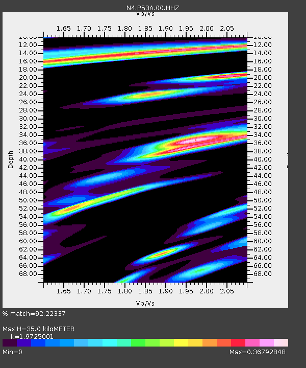
| Estimated Moho Depth: |
35.0 km |
| Estimated Crust Vp/Vs: |
1.97 |
| Assumed Crust Vp: |
6.207 km/s |
| Estimated Crust Vs: |
3.147 km/s |
| Estimated Crust Poisson's Ratio: |
0.33 |
|
| Radial Match: |
92.22337 % |
| Radial Bump: |
309 |
| Transverse Match: |
62.65182 % |
| Transverse Bump: |
336 |
| SOD ConfigId: |
23341671 |
| Insert Time: |
2021-01-12 12:34:27.958 +0000 |
| GWidth: |
2.5 |
| Max Bumps: |
400 |
| Tol: |
0.001 |
|

Signal To Noise
| Channel | StoN | STA | LTA |
| N4:P53A:00:HHZ:20201229T11:30:22.109023Z | 7.022471 | 9.552346E-7 | 1.3602542E-7 |
| N4:P53A:00:HH1:20201229T11:30:22.109023Z | 1.8066822 | 3.116402E-7 | 1.7249309E-7 |
| N4:P53A:00:HH2:20201229T11:30:22.109023Z | 1.8563541 | 2.8592E-7 | 1.5402235E-7 |
| Arrivals |
| Ps | 5.7 SECOND |
| PpPs | 16 SECOND |
| PsPs/PpSs | 22 SECOND |


