You are here: Home > Network List > IU - Global Seismograph Network (GSN - IRIS/USGS) Stations List
> Station POHA Pohakuloa, Hawaii, USA > Earthquake Result Viewer
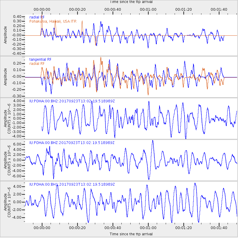
POHA Pohakuloa, Hawaii, USA - Earthquake Result Viewer
*The percent match for this event was below the threshold and hence no stack was calculated.
| Earthquake location: |
Oaxaca, Mexico |
| Earthquake latitude/longitude: |
16.7/-94.9 |
| Earthquake time(UTC): |
2017/09/23 (266) 12:53:02 GMT |
| Earthquake Depth: |
9.1 km |
| Earthquake Magnitude: |
6.1 Mww |
| Earthquake Catalog/Contributor: |
NEIC PDE/us |
|
| Network: |
IU Global Seismograph Network (GSN - IRIS/USGS) |
| Station: |
POHA Pohakuloa, Hawaii, USA |
| Lat/Lon: |
19.76 N/155.53 W |
| Elevation: |
1990 m |
|
| Distance: |
57.4 deg |
| Az: |
283.005 deg |
| Baz: |
82.383 deg |
| Ray Param: |
$rayparam |
*The percent match for this event was below the threshold and hence was not used in the summary stack. |
|
| Radial Match: |
43.980717 % |
| Radial Bump: |
394 |
| Transverse Match: |
50.757954 % |
| Transverse Bump: |
390 |
| SOD ConfigId: |
2364251 |
| Insert Time: |
2017-10-09 20:44:46.566 +0000 |
| GWidth: |
2.5 |
| Max Bumps: |
400 |
| Tol: |
0.001 |
|
Signal To Noise
| Channel | StoN | STA | LTA |
| IU:POHA:00:BHZ:20170923T13:02:19.518989Z | 2.0037925 | 2.9279724E-6 | 1.4612154E-6 |
| IU:POHA:00:BH1:20170923T13:02:19.518989Z | 1.292462 | 1.9515237E-6 | 1.5099273E-6 |
| IU:POHA:00:BH2:20170923T13:02:19.518989Z | 0.9758072 | 1.7552202E-6 | 1.7987367E-6 |
| Arrivals |
| Ps | |
| PpPs | |
| PsPs/PpSs | |


