You are here: Home > Network List > IU - Global Seismograph Network (GSN - IRIS/USGS) Stations List
> Station SAML Samuel, Brazil > Earthquake Result Viewer
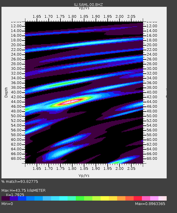
SAML Samuel, Brazil - Earthquake Result Viewer
| Earthquake location: |
Oaxaca, Mexico |
| Earthquake latitude/longitude: |
16.7/-94.9 |
| Earthquake time(UTC): |
2017/09/23 (266) 12:53:02 GMT |
| Earthquake Depth: |
9.1 km |
| Earthquake Magnitude: |
6.1 Mww |
| Earthquake Catalog/Contributor: |
NEIC PDE/us |
|
| Network: |
IU Global Seismograph Network (GSN - IRIS/USGS) |
| Station: |
SAML Samuel, Brazil |
| Lat/Lon: |
8.95 S/63.18 W |
| Elevation: |
120 m |
|
| Distance: |
40.5 deg |
| Az: |
126.77 deg |
| Baz: |
309.029 deg |
| Ray Param: |
0.074377626 |
| Estimated Moho Depth: |
43.75 km |
| Estimated Crust Vp/Vs: |
1.79 |
| Assumed Crust Vp: |
6.498 km/s |
| Estimated Crust Vs: |
3.625 km/s |
| Estimated Crust Poisson's Ratio: |
0.27 |
|
| Radial Match: |
93.82775 % |
| Radial Bump: |
279 |
| Transverse Match: |
72.60109 % |
| Transverse Bump: |
400 |
| SOD ConfigId: |
2364251 |
| Insert Time: |
2017-10-09 20:44:51.000 +0000 |
| GWidth: |
2.5 |
| Max Bumps: |
400 |
| Tol: |
0.001 |
|

Signal To Noise
| Channel | StoN | STA | LTA |
| IU:SAML:00:BHZ:20170923T13:00:10.319008Z | 49.108986 | 3.0879937E-6 | 6.288042E-8 |
| IU:SAML:00:BH1:20170923T13:00:10.319008Z | 27.220324 | 1.7953698E-6 | 6.595696E-8 |
| IU:SAML:00:BH2:20170923T13:00:10.319008Z | 3.6731162 | 3.9349598E-7 | 1.0712865E-7 |
| Arrivals |
| Ps | 5.7 SECOND |
| PpPs | 18 SECOND |
| PsPs/PpSs | 23 SECOND |


